You are here: Home > Network List > US - United States National Seismic Network Stations List
> Station CBKS Cedar Bluff, Kansas, USA > Earthquake Result Viewer
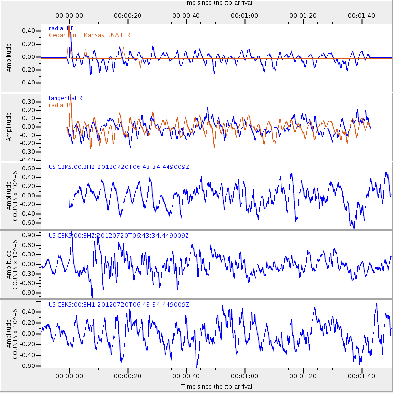
CBKS Cedar Bluff, Kansas, USA - Earthquake Result Viewer
*The percent match for this event was below the threshold and hence no stack was calculated.
| Earthquake location: |
Kuril Islands |
| Earthquake latitude/longitude: |
49.4/156.1 |
| Earthquake time(UTC): |
2012/07/20 (202) 06:32:56 GMT |
| Earthquake Depth: |
10 km |
| Earthquake Magnitude: |
5.8 MB, 5.5 MS, 5.8 MW, 5.9 MW |
| Earthquake Catalog/Contributor: |
WHDF/NEIC |
|
| Network: |
US United States National Seismic Network |
| Station: |
CBKS Cedar Bluff, Kansas, USA |
| Lat/Lon: |
38.81 N/99.74 W |
| Elevation: |
677 m |
|
| Distance: |
69.7 deg |
| Az: |
53.898 deg |
| Baz: |
317.447 deg |
| Ray Param: |
$rayparam |
*The percent match for this event was below the threshold and hence was not used in the summary stack. |
|
| Radial Match: |
59.862904 % |
| Radial Bump: |
400 |
| Transverse Match: |
67.10276 % |
| Transverse Bump: |
400 |
| SOD ConfigId: |
558545 |
| Insert Time: |
2013-09-19 22:42:26.932 +0000 |
| GWidth: |
2.5 |
| Max Bumps: |
400 |
| Tol: |
0.001 |
|
Signal To Noise
| Channel | StoN | STA | LTA |
| US:CBKS:00:BHZ:20120720T06:43:34.449009Z | 3.7815948 | 3.4685178E-7 | 9.1721034E-8 |
| US:CBKS:00:BH1:20120720T06:43:34.449009Z | 0.967137 | 1.7384592E-7 | 1.7975314E-7 |
| US:CBKS:00:BH2:20120720T06:43:34.449009Z | 1.5657697 | 2.8134406E-7 | 1.7968418E-7 |
| Arrivals |
| Ps | |
| PpPs | |
| PsPs/PpSs | |


