You are here: Home > Network List > AU - Australian Seismological Centre Stations List
> Station NWAO Narrogin, Western Australia > Earthquake Result Viewer
NWAO Narrogin, Western Australia - Earthquake Result Viewer
| Earthquake location: |
Mariana Islands |
| Earthquake latitude/longitude: |
13.8/144.4 |
| Earthquake time(UTC): |
2014/09/17 (260) 06:14:46 GMT |
| Earthquake Depth: |
137 km |
| Earthquake Magnitude: |
6.7 MWC, 7.1 MI |
| Earthquake Catalog/Contributor: |
NEIC PDE/NEIC COMCAT |
|
| Network: |
AU Australian Seismological Centre |
| Station: |
NWAO Narrogin, Western Australia |
| Lat/Lon: |
32.93 S/117.24 E |
| Elevation: |
265 m |
|
| Distance: |
53.2 deg |
| Az: |
208.655 deg |
| Baz: |
33.644 deg |
| Ray Param: |
0.06580775 |
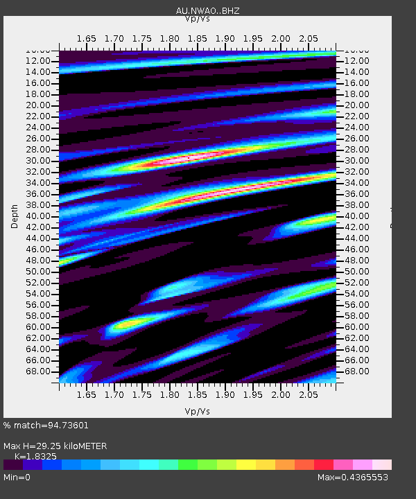
| Estimated Moho Depth: |
29.25 km |
| Estimated Crust Vp/Vs: |
1.83 |
| Assumed Crust Vp: |
6.419 km/s |
| Estimated Crust Vs: |
3.503 km/s |
| Estimated Crust Poisson's Ratio: |
0.29 |
|
| Radial Match: |
94.73601 % |
| Radial Bump: |
296 |
| Transverse Match: |
69.02307 % |
| Transverse Bump: |
400 |
| SOD ConfigId: |
3390531 |
| Insert Time: |
2019-04-14 02:27:53.671 +0000 |
| GWidth: |
2.5 |
| Max Bumps: |
400 |
| Tol: |
0.001 |
|

Signal To Noise
| Channel | StoN | STA | LTA |
| AU:NWAO: :BHZ:20140917T06:23:19.700Z | 9.02019 | 1.4556698E-5 | 1.6137907E-6 |
| AU:NWAO: :BHN:20140917T06:23:19.700Z | 7.600325 | 6.9265047E-6 | 9.1134325E-7 |
| AU:NWAO: :BHE:20140917T06:23:19.700Z | 3.859541 | 3.5667658E-6 | 9.241425E-7 |
| Arrivals |
| Ps | 4.0 SECOND |
| PpPs | 12 SECOND |
| PsPs/PpSs | 16 SECOND |


