You are here: Home > Network List > IU - Global Seismograph Network (GSN - IRIS/USGS) Stations List
> Station PMG Port Moresby, New Guinea > Earthquake Result Viewer
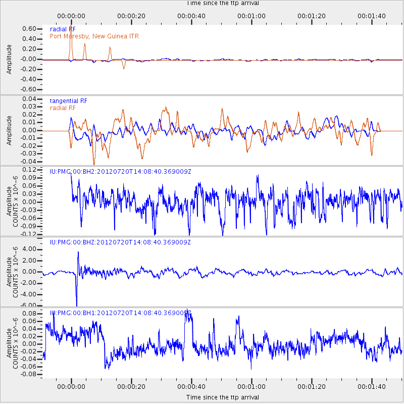
PMG Port Moresby, New Guinea - Earthquake Result Viewer
*The percent match for this event was below the threshold and hence no stack was calculated.
| Earthquake location: |
Fiji Islands Region |
| Earthquake latitude/longitude: |
-21.2/-179.3 |
| Earthquake time(UTC): |
2012/07/20 (202) 14:03:13 GMT |
| Earthquake Depth: |
625 km |
| Earthquake Magnitude: |
5.6 MB, 5.6 MW, 5.5 MW |
| Earthquake Catalog/Contributor: |
WHDF/NEIC |
|
| Network: |
IU Global Seismograph Network (GSN - IRIS/USGS) |
| Station: |
PMG Port Moresby, New Guinea |
| Lat/Lon: |
9.40 S/147.16 E |
| Elevation: |
90 m |
|
| Distance: |
34.3 deg |
| Az: |
284.836 deg |
| Baz: |
113.933 deg |
| Ray Param: |
$rayparam |
*The percent match for this event was below the threshold and hence was not used in the summary stack. |
|
| Radial Match: |
39.369007 % |
| Radial Bump: |
400 |
| Transverse Match: |
41.10633 % |
| Transverse Bump: |
400 |
| SOD ConfigId: |
558545 |
| Insert Time: |
2013-09-19 22:44:47.886 +0000 |
| GWidth: |
2.5 |
| Max Bumps: |
400 |
| Tol: |
0.001 |
|
Signal To Noise
| Channel | StoN | STA | LTA |
| IU:PMG:00:BHZ:20120720T14:08:40.369009Z | 4.76656 | 1.5411531E-6 | 3.2332608E-7 |
| IU:PMG:00:BH1:20120720T14:08:40.369009Z | 1.3293808 | 4.156431E-8 | 3.126592E-8 |
| IU:PMG:00:BH2:20120720T14:08:40.369009Z | 0.8504423 | 2.749291E-8 | 3.232778E-8 |
| Arrivals |
| Ps | |
| PpPs | |
| PsPs/PpSs | |


