You are here: Home > Network List > CB - China National Seismic Network Stations List
> Station HHC Huhehaote,Neimeng Province > Earthquake Result Viewer
HHC Huhehaote,Neimeng Province - Earthquake Result Viewer
| Earthquake location: |
Mariana Islands |
| Earthquake latitude/longitude: |
13.8/144.4 |
| Earthquake time(UTC): |
2014/09/17 (260) 06:14:46 GMT |
| Earthquake Depth: |
137 km |
| Earthquake Magnitude: |
6.7 MWC, 7.1 MI |
| Earthquake Catalog/Contributor: |
NEIC PDE/NEIC COMCAT |
|
| Network: |
CB China National Seismic Network |
| Station: |
HHC Huhehaote,Neimeng Province |
| Lat/Lon: |
40.85 N/111.56 E |
| Elevation: |
1169 m |
|
| Distance: |
39.3 deg |
| Az: |
319.555 deg |
| Baz: |
123.803 deg |
| Ray Param: |
0.07454241 |
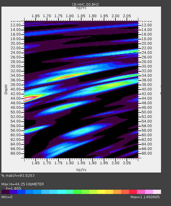
| Estimated Moho Depth: |
44.25 km |
| Estimated Crust Vp/Vs: |
1.61 |
| Assumed Crust Vp: |
6.384 km/s |
| Estimated Crust Vs: |
3.978 km/s |
| Estimated Crust Poisson's Ratio: |
0.18 |
|
| Radial Match: |
93.5283 % |
| Radial Bump: |
400 |
| Transverse Match: |
70.233955 % |
| Transverse Bump: |
400 |
| SOD ConfigId: |
3390531 |
| Insert Time: |
2019-04-14 02:28:17.135 +0000 |
| GWidth: |
2.5 |
| Max Bumps: |
400 |
| Tol: |
0.001 |
|

Signal To Noise
| Channel | StoN | STA | LTA |
| CB:HHC:00:BHZ:20140917T06:21:31.240009Z | 73.46537 | 1.6826129E-5 | 2.2903482E-7 |
| CB:HHC:00:BHN:20140917T06:21:31.240009Z | 22.748781 | 4.872112E-6 | 2.1417024E-7 |
| CB:HHC:00:BHE:20140917T06:21:31.240009Z | 33.81563 | 7.98113E-6 | 2.3601893E-7 |
| Arrivals |
| Ps | 4.5 SECOND |
| PpPs | 17 SECOND |
| PsPs/PpSs | 21 SECOND |


