You are here: Home > Network List > US - United States National Seismic Network Stations List
> Station MNTX Cornudas Mountains, Texas, USA > Earthquake Result Viewer
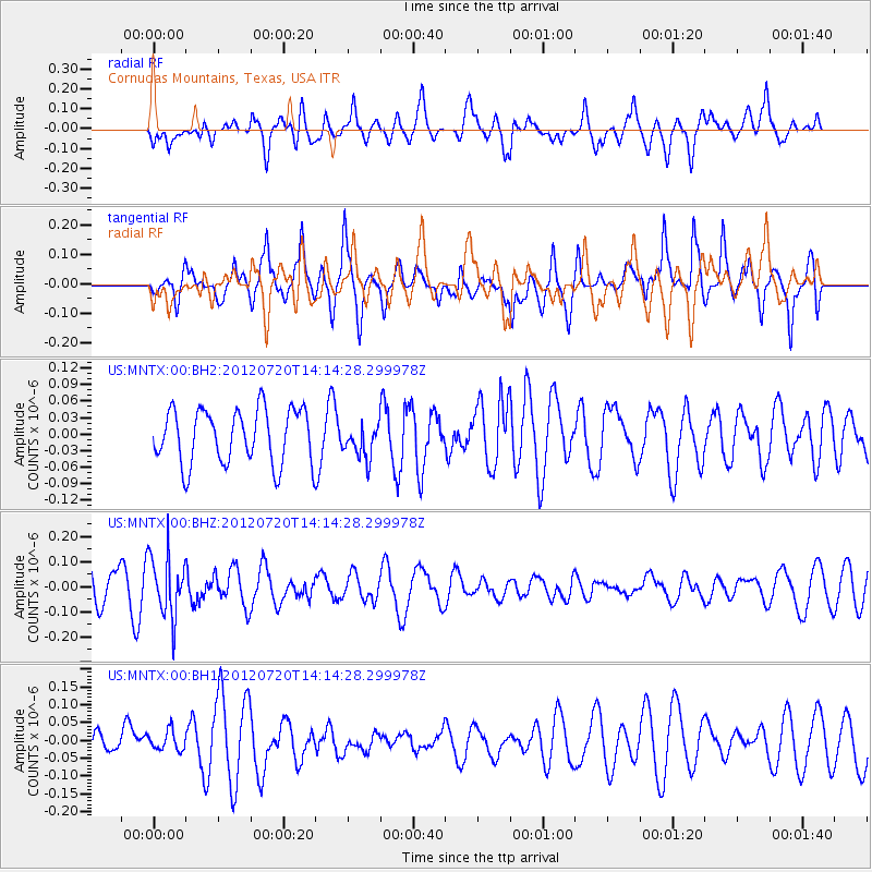
MNTX Cornudas Mountains, Texas, USA - Earthquake Result Viewer
*The percent match for this event was below the threshold and hence no stack was calculated.
| Earthquake location: |
Fiji Islands Region |
| Earthquake latitude/longitude: |
-21.2/-179.3 |
| Earthquake time(UTC): |
2012/07/20 (202) 14:03:13 GMT |
| Earthquake Depth: |
625 km |
| Earthquake Magnitude: |
5.6 MB, 5.6 MW, 5.5 MW |
| Earthquake Catalog/Contributor: |
WHDF/NEIC |
|
| Network: |
US United States National Seismic Network |
| Station: |
MNTX Cornudas Mountains, Texas, USA |
| Lat/Lon: |
31.70 N/105.38 W |
| Elevation: |
404 m |
|
| Distance: |
88.1 deg |
| Az: |
55.026 deg |
| Baz: |
243.753 deg |
| Ray Param: |
$rayparam |
*The percent match for this event was below the threshold and hence was not used in the summary stack. |
|
| Radial Match: |
60.38889 % |
| Radial Bump: |
400 |
| Transverse Match: |
65.559326 % |
| Transverse Bump: |
400 |
| SOD ConfigId: |
558545 |
| Insert Time: |
2013-09-19 22:45:19.048 +0000 |
| GWidth: |
2.5 |
| Max Bumps: |
400 |
| Tol: |
0.001 |
|
Signal To Noise
| Channel | StoN | STA | LTA |
| US:MNTX:00:BHZ:20120720T14:14:28.299978Z | 2.0838354 | 1.2154194E-7 | 5.8326073E-8 |
| US:MNTX:00:BH1:20120720T14:14:28.299978Z | 0.7706212 | 2.8354469E-8 | 3.67943E-8 |
| US:MNTX:00:BH2:20120720T14:14:28.299978Z | 0.62381893 | 3.0855226E-8 | 4.946183E-8 |
| Arrivals |
| Ps | |
| PpPs | |
| PsPs/PpSs | |


