You are here: Home > Network List > IU - Global Seismograph Network (GSN - IRIS/USGS) Stations List
> Station PMG Port Moresby, New Guinea > Earthquake Result Viewer
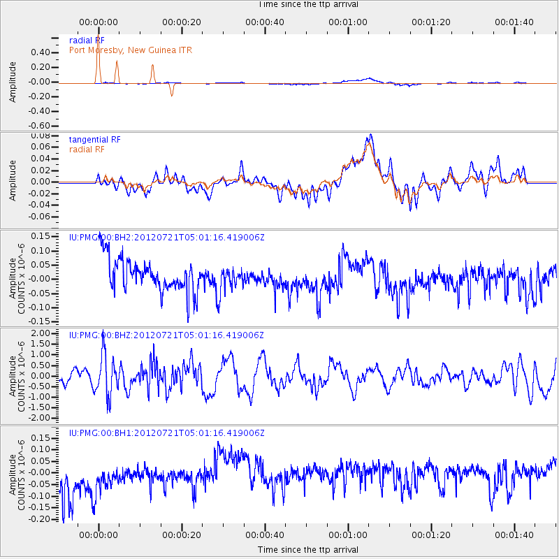
PMG Port Moresby, New Guinea - Earthquake Result Viewer
*The percent match for this event was below the threshold and hence no stack was calculated.
| Earthquake location: |
East Of North Island, N.Z. |
| Earthquake latitude/longitude: |
-37.7/-180.0 |
| Earthquake time(UTC): |
2012/07/21 (203) 04:54:05 GMT |
| Earthquake Depth: |
12 km |
| Earthquake Magnitude: |
5.7 MB, 5.5 MS, 5.6 MW, 5.7 MW |
| Earthquake Catalog/Contributor: |
WHDF/NEIC |
|
| Network: |
IU Global Seismograph Network (GSN - IRIS/USGS) |
| Station: |
PMG Port Moresby, New Guinea |
| Lat/Lon: |
9.40 S/147.16 E |
| Elevation: |
90 m |
|
| Distance: |
40.9 deg |
| Az: |
305.076 deg |
| Baz: |
138.87 deg |
| Ray Param: |
$rayparam |
*The percent match for this event was below the threshold and hence was not used in the summary stack. |
|
| Radial Match: |
23.537935 % |
| Radial Bump: |
400 |
| Transverse Match: |
25.79499 % |
| Transverse Bump: |
400 |
| SOD ConfigId: |
558545 |
| Insert Time: |
2013-09-19 22:46:33.841 +0000 |
| GWidth: |
2.5 |
| Max Bumps: |
400 |
| Tol: |
0.001 |
|
Signal To Noise
| Channel | StoN | STA | LTA |
| IU:PMG:00:BHZ:20120721T05:01:16.419006Z | 4.2205076 | 9.723116E-7 | 2.3037788E-7 |
| IU:PMG:00:BH1:20120721T05:01:16.419006Z | 0.68904823 | 1.5594449E-7 | 2.2631868E-7 |
| IU:PMG:00:BH2:20120721T05:01:16.419006Z | 0.66286975 | 3.8849322E-8 | 5.8607778E-8 |
| Arrivals |
| Ps | |
| PpPs | |
| PsPs/PpSs | |


