You are here: Home > Network List > PF - Volcanologic Network of Piton de Fournaise-OVPF Stations List
> Station HIM cratere Himiltrude > Earthquake Result Viewer
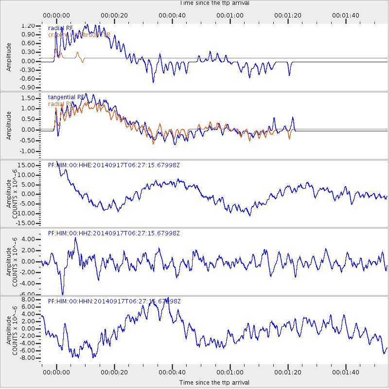
HIM cratere Himiltrude - Earthquake Result Viewer
*The percent match for this event was below the threshold and hence no stack was calculated.
| Earthquake location: |
Mariana Islands |
| Earthquake latitude/longitude: |
13.8/144.4 |
| Earthquake time(UTC): |
2014/09/17 (260) 06:14:46 GMT |
| Earthquake Depth: |
137 km |
| Earthquake Magnitude: |
6.7 MWC, 7.1 MI |
| Earthquake Catalog/Contributor: |
NEIC PDE/NEIC COMCAT |
|
| Network: |
PF Volcanologic Network of Piton de Fournaise-OVPF |
| Station: |
HIM cratere Himiltrude |
| Lat/Lon: |
21.21 S/55.72 E |
| Elevation: |
1958 m |
|
| Distance: |
93.7 deg |
| Az: |
249.186 deg |
| Baz: |
76.761 deg |
| Ray Param: |
$rayparam |
*The percent match for this event was below the threshold and hence was not used in the summary stack. |
|
| Radial Match: |
22.841068 % |
| Radial Bump: |
400 |
| Transverse Match: |
21.589485 % |
| Transverse Bump: |
400 |
| SOD ConfigId: |
3390531 |
| Insert Time: |
2019-04-14 02:30:07.765 +0000 |
| GWidth: |
2.5 |
| Max Bumps: |
400 |
| Tol: |
0.001 |
|
Signal To Noise
| Channel | StoN | STA | LTA |
| PF:HIM:00:HHZ:20140917T06:27:15.67998Z | 3.2056088 | 2.4850701E-6 | 7.752256E-7 |
| PF:HIM:00:HHN:20140917T06:27:15.67998Z | 0.59888655 | 3.4189898E-6 | 5.7089105E-6 |
| PF:HIM:00:HHE:20140917T06:27:15.67998Z | 0.7757678 | 5.162386E-6 | 6.654551E-6 |
| Arrivals |
| Ps | |
| PpPs | |
| PsPs/PpSs | |


