You are here: Home > Network List > TO - Tectonic Observatory Stations List
> Station CC04 CCSE CC04 > Earthquake Result Viewer
CC04 CCSE CC04 - Earthquake Result Viewer
| Earthquake location: |
Mariana Islands |
| Earthquake latitude/longitude: |
13.8/144.4 |
| Earthquake time(UTC): |
2014/09/17 (260) 06:14:46 GMT |
| Earthquake Depth: |
137 km |
| Earthquake Magnitude: |
6.7 MWC, 7.1 MI |
| Earthquake Catalog/Contributor: |
NEIC PDE/NEIC COMCAT |
|
| Network: |
TO Tectonic Observatory |
| Station: |
CC04 CCSE CC04 |
| Lat/Lon: |
36.02 N/121.25 W |
| Elevation: |
337 m |
|
| Distance: |
85.5 deg |
| Az: |
54.183 deg |
| Baz: |
283.619 deg |
| Ray Param: |
0.044418443 |
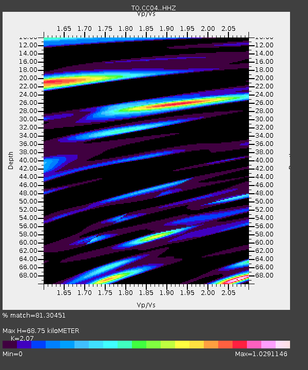
| Estimated Moho Depth: |
68.75 km |
| Estimated Crust Vp/Vs: |
2.07 |
| Assumed Crust Vp: |
6.391 km/s |
| Estimated Crust Vs: |
3.087 km/s |
| Estimated Crust Poisson's Ratio: |
0.35 |
|
| Radial Match: |
81.30451 % |
| Radial Bump: |
400 |
| Transverse Match: |
80.92481 % |
| Transverse Bump: |
400 |
| SOD ConfigId: |
3390531 |
| Insert Time: |
2019-04-14 02:30:40.693 +0000 |
| GWidth: |
2.5 |
| Max Bumps: |
400 |
| Tol: |
0.001 |
|

Signal To Noise
| Channel | StoN | STA | LTA |
| TO:CC04: :HHZ:20140917T06:26:36.47002Z | 27.596933 | 1.9288322E-5 | 6.9892985E-7 |
| TO:CC04: :HHN:20140917T06:26:36.47002Z | 9.954981 | 2.4182564E-6 | 2.429192E-7 |
| TO:CC04: :HHE:20140917T06:26:36.47002Z | 12.663843 | 6.2088648E-6 | 4.9028284E-7 |
| Arrivals |
| Ps | 12 SECOND |
| PpPs | 32 SECOND |
| PsPs/PpSs | 44 SECOND |


