You are here: Home > Network List > IU - Global Seismograph Network (GSN - IRIS/USGS) Stations List
> Station GUMO Guam, Mariana Islands > Earthquake Result Viewer
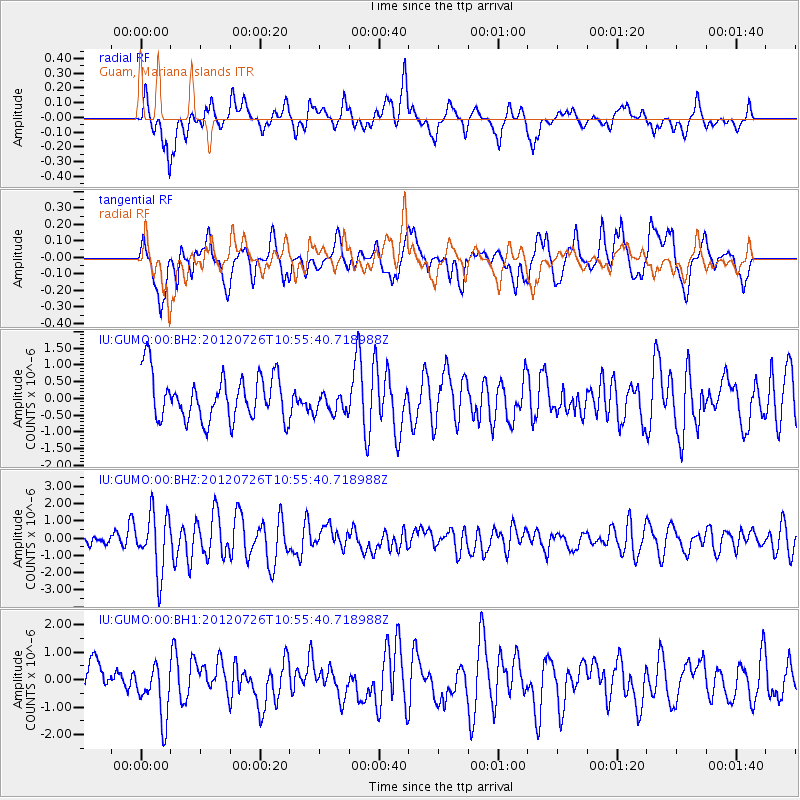
GUMO Guam, Mariana Islands - Earthquake Result Viewer
*The percent match for this event was below the threshold and hence no stack was calculated.
| Earthquake location: |
Southeast Of Loyalty Islands |
| Earthquake latitude/longitude: |
-21.1/169.5 |
| Earthquake time(UTC): |
2012/07/26 (208) 10:48:22 GMT |
| Earthquake Depth: |
33 km |
| Earthquake Magnitude: |
5.6 MW, 5.4 MS, 5.2 MB |
| Earthquake Catalog/Contributor: |
WHDF/NEIC |
|
| Network: |
IU Global Seismograph Network (GSN - IRIS/USGS) |
| Station: |
GUMO Guam, Mariana Islands |
| Lat/Lon: |
13.59 N/144.87 E |
| Elevation: |
170 m |
|
| Distance: |
42.1 deg |
| Az: |
322.814 deg |
| Baz: |
144.521 deg |
| Ray Param: |
$rayparam |
*The percent match for this event was below the threshold and hence was not used in the summary stack. |
|
| Radial Match: |
64.08709 % |
| Radial Bump: |
400 |
| Transverse Match: |
59.25916 % |
| Transverse Bump: |
400 |
| SOD ConfigId: |
558545 |
| Insert Time: |
2013-09-19 22:58:13.376 +0000 |
| GWidth: |
2.5 |
| Max Bumps: |
400 |
| Tol: |
0.001 |
|
Signal To Noise
| Channel | StoN | STA | LTA |
| IU:GUMO:00:BHZ:20120726T10:55:40.718988Z | 4.39743 | 1.6994426E-6 | 3.864627E-7 |
| IU:GUMO:00:BH1:20120726T10:55:40.718988Z | 1.3970424 | 9.871479E-7 | 7.065984E-7 |
| IU:GUMO:00:BH2:20120726T10:55:40.718988Z | 0.5284429 | 3.5611143E-7 | 6.7388817E-7 |
| Arrivals |
| Ps | |
| PpPs | |
| PsPs/PpSs | |


