You are here: Home > Network List > TO - Tectonic Observatory Stations List
> Station CC06 CCSE CC06 > Earthquake Result Viewer
CC06 CCSE CC06 - Earthquake Result Viewer
| Earthquake location: |
Mariana Islands |
| Earthquake latitude/longitude: |
13.8/144.4 |
| Earthquake time(UTC): |
2014/09/17 (260) 06:14:46 GMT |
| Earthquake Depth: |
137 km |
| Earthquake Magnitude: |
6.7 MWC, 7.1 MI |
| Earthquake Catalog/Contributor: |
NEIC PDE/NEIC COMCAT |
|
| Network: |
TO Tectonic Observatory |
| Station: |
CC06 CCSE CC06 |
| Lat/Lon: |
35.98 N/121.12 W |
| Elevation: |
366 m |
|
| Distance: |
85.6 deg |
| Az: |
54.189 deg |
| Baz: |
283.698 deg |
| Ray Param: |
0.044338368 |
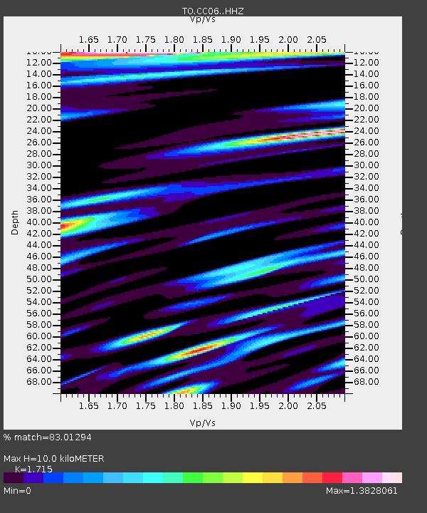
| Estimated Moho Depth: |
10.0 km |
| Estimated Crust Vp/Vs: |
1.72 |
| Assumed Crust Vp: |
6.183 km/s |
| Estimated Crust Vs: |
3.605 km/s |
| Estimated Crust Poisson's Ratio: |
0.24 |
|
| Radial Match: |
83.01294 % |
| Radial Bump: |
400 |
| Transverse Match: |
73.97344 % |
| Transverse Bump: |
400 |
| SOD ConfigId: |
3390531 |
| Insert Time: |
2019-04-14 02:30:43.902 +0000 |
| GWidth: |
2.5 |
| Max Bumps: |
400 |
| Tol: |
0.001 |
|

Signal To Noise
| Channel | StoN | STA | LTA |
| TO:CC06: :HHZ:20140917T06:26:37.030017Z | 56.228477 | 2.2396422E-5 | 3.9831102E-7 |
| TO:CC06: :HHN:20140917T06:26:37.030017Z | 4.795503 | 3.3915896E-6 | 7.0724377E-7 |
| TO:CC06: :HHE:20140917T06:26:37.030017Z | 7.1405377 | 4.4828257E-6 | 6.2779947E-7 |
| Arrivals |
| Ps | 1.2 SECOND |
| PpPs | 4.3 SECOND |
| PsPs/PpSs | 5.5 SECOND |


