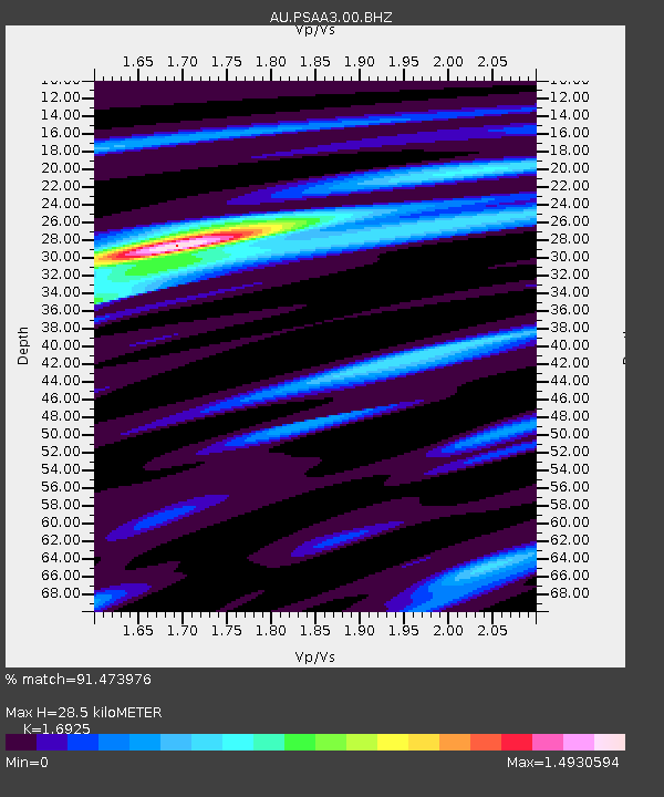
PSAA3 Pilbara Seismic Array Element A3 - Earthquake Result Viewer

Earthquake location: New Ireland Region, P.N.G.
Earthquake latitude/longitude: -4.7/153.2
Earthquake time(UTC): 2012/07/28 (210) 20:03:56 GMT
Earthquake Depth: 41 km
Earthquake Magnitude: 6.1 MB, 6.3 MS, 6.5 MW, 6.5 MW
Earthquake Catalog/Contributor: WHDF/NEIC
Network: AU Australian Seismological Centre
Station: PSAA3 Pilbara Seismic Array Element A3
Lat/Lon: 21.58 S/119.85 E
Elevation: 315 m
Distance: 36.4 deg
Az: 239.446 deg
Baz: 67.251 deg
Ray Param: 0.076600544
Estimated Moho Depth: 28.5 km
Estimated Crust Vp/Vs: 1.69
Assumed Crust Vp: 6.464 km/s
Estimated Crust Vs: 3.819 km/s
Estimated Crust Poisson's Ratio: 0.23
Radial Match: 91.473976 %
Radial Bump: 339
Transverse Match: 68.630325 %
Transverse Bump: 400
SOD ConfigId: 558545
Insert Time: 2013-09-19 22:59:08.442 +0000
GWidth: 2.5
Max Bumps: 400
Tol: 0.001

Signal To Noise

ChannelStoNSTALTA
AU:PSAA3:00:BHZ:20120728T20:10:27.094006Z9.9033562.2038432E-62.2253501E-7
AU:PSAA3:00:BH1:20120728T20:10:27.094006Z2.62213925.594852E-72.1336974E-7
AU:PSAA3:00:BH2:20120728T20:10:27.094006Z5.11085461.4207988E-62.7799632E-7
Arrivals
Ps3.3 SECOND
PpPs11 SECOND
PsPs/PpSs14 SECOND