You are here: Home > Network List > TO - Tectonic Observatory Stations List
> Station CC31 CCSE CC31 > Earthquake Result Viewer
CC31 CCSE CC31 - Earthquake Result Viewer
| Earthquake location: |
Mariana Islands |
| Earthquake latitude/longitude: |
13.8/144.4 |
| Earthquake time(UTC): |
2014/09/17 (260) 06:14:46 GMT |
| Earthquake Depth: |
137 km |
| Earthquake Magnitude: |
6.7 MWC, 7.1 MI |
| Earthquake Catalog/Contributor: |
NEIC PDE/NEIC COMCAT |
|
| Network: |
TO Tectonic Observatory |
| Station: |
CC31 CCSE CC31 |
| Lat/Lon: |
36.32 N/119.27 W |
| Elevation: |
93 m |
|
| Distance: |
87.0 deg |
| Az: |
53.498 deg |
| Baz: |
284.735 deg |
| Ray Param: |
0.043361813 |
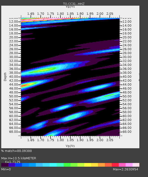
| Estimated Moho Depth: |
10.5 km |
| Estimated Crust Vp/Vs: |
1.71 |
| Assumed Crust Vp: |
6.291 km/s |
| Estimated Crust Vs: |
3.674 km/s |
| Estimated Crust Poisson's Ratio: |
0.24 |
|
| Radial Match: |
88.09388 % |
| Radial Bump: |
400 |
| Transverse Match: |
74.10558 % |
| Transverse Bump: |
400 |
| SOD ConfigId: |
3390531 |
| Insert Time: |
2019-04-14 02:30:59.689 +0000 |
| GWidth: |
2.5 |
| Max Bumps: |
400 |
| Tol: |
0.001 |
|

Signal To Noise
| Channel | StoN | STA | LTA |
| TO:CC31: :HHZ:20140917T06:26:43.669971Z | 28.987524 | 1.365997E-5 | 4.7123618E-7 |
| TO:CC31: :HHN:20140917T06:26:43.669971Z | 12.9641485 | 3.2027797E-6 | 2.4704897E-7 |
| TO:CC31: :HHE:20140917T06:26:43.669971Z | 15.906124 | 6.5889444E-6 | 4.1423945E-7 |
| Arrivals |
| Ps | 1.2 SECOND |
| PpPs | 4.4 SECOND |
| PsPs/PpSs | 5.6 SECOND |


