You are here: Home > Network List > TO - Tectonic Observatory Stations List
> Station CC33 CCSE CC33 > Earthquake Result Viewer
CC33 CCSE CC33 - Earthquake Result Viewer
| Earthquake location: |
Mariana Islands |
| Earthquake latitude/longitude: |
13.8/144.4 |
| Earthquake time(UTC): |
2014/09/17 (260) 06:14:46 GMT |
| Earthquake Depth: |
137 km |
| Earthquake Magnitude: |
6.7 MWC, 7.1 MI |
| Earthquake Catalog/Contributor: |
NEIC PDE/NEIC COMCAT |
|
| Network: |
TO Tectonic Observatory |
| Station: |
CC33 CCSE CC33 |
| Lat/Lon: |
36.34 N/119.12 W |
| Elevation: |
126 m |
|
| Distance: |
87.1 deg |
| Az: |
53.441 deg |
| Baz: |
284.821 deg |
| Ray Param: |
0.043284003 |
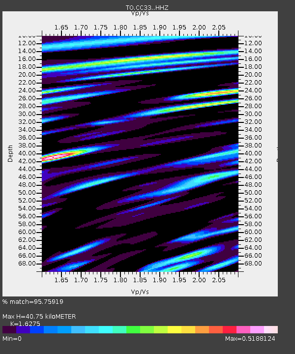
| Estimated Moho Depth: |
40.75 km |
| Estimated Crust Vp/Vs: |
1.63 |
| Assumed Crust Vp: |
6.291 km/s |
| Estimated Crust Vs: |
3.866 km/s |
| Estimated Crust Poisson's Ratio: |
0.20 |
|
| Radial Match: |
95.75919 % |
| Radial Bump: |
400 |
| Transverse Match: |
82.33654 % |
| Transverse Bump: |
400 |
| SOD ConfigId: |
3390531 |
| Insert Time: |
2019-04-14 02:31:00.004 +0000 |
| GWidth: |
2.5 |
| Max Bumps: |
400 |
| Tol: |
0.001 |
|

Signal To Noise
| Channel | StoN | STA | LTA |
| TO:CC33: :HHZ:20140917T06:26:44.21001Z | 46.36707 | 1.1727459E-5 | 2.5292647E-7 |
| TO:CC33: :HHN:20140917T06:26:44.21001Z | 20.17502 | 1.7848488E-6 | 8.8468255E-8 |
| TO:CC33: :HHE:20140917T06:26:44.21001Z | 23.596157 | 4.6138907E-6 | 1.9553569E-7 |
| Arrivals |
| Ps | 4.2 SECOND |
| PpPs | 17 SECOND |
| PsPs/PpSs | 21 SECOND |


