You are here: Home > Network List > US - United States National Seismic Network Stations List
> Station EGAK Eagle, Central Alaska, Alaska, USA > Earthquake Result Viewer
EGAK Eagle, Central Alaska, Alaska, USA - Earthquake Result Viewer

| Earthquake location: |
New Ireland Region, P.N.G. |
| Earthquake latitude/longitude: |
-4.7/153.2 |
| Earthquake time(UTC): |
2012/07/28 (210) 20:03:56 GMT |
| Earthquake Depth: |
41 km |
| Earthquake Magnitude: |
6.1 MB, 6.3 MS, 6.5 MW, 6.5 MW |
| Earthquake Catalog/Contributor: |
WHDF/NEIC |
|
| Network: |
US United States National Seismic Network |
| Station: |
EGAK Eagle, Central Alaska, Alaska, USA |
| Lat/Lon: |
64.78 N/141.16 W |
| Elevation: |
297 m |
|
| Distance: |
84.1 deg |
| Az: |
23.111 deg |
| Baz: |
245.936 deg |
| Ray Param: |
0.045674153 |
| Estimated Moho Depth: |
33.5 km |
| Estimated Crust Vp/Vs: |
1.65 |
| Assumed Crust Vp: |
6.566 km/s |
| Estimated Crust Vs: |
3.98 km/s |
| Estimated Crust Poisson's Ratio: |
0.21 |
|
| Radial Match: |
94.98068 % |
| Radial Bump: |
400 |
| Transverse Match: |
82.702934 % |
| Transverse Bump: |
400 |
| SOD ConfigId: |
558545 |
| Insert Time: |
2013-09-19 23:01:08.864 +0000 |
| GWidth: |
2.5 |
| Max Bumps: |
400 |
| Tol: |
0.001 |
|
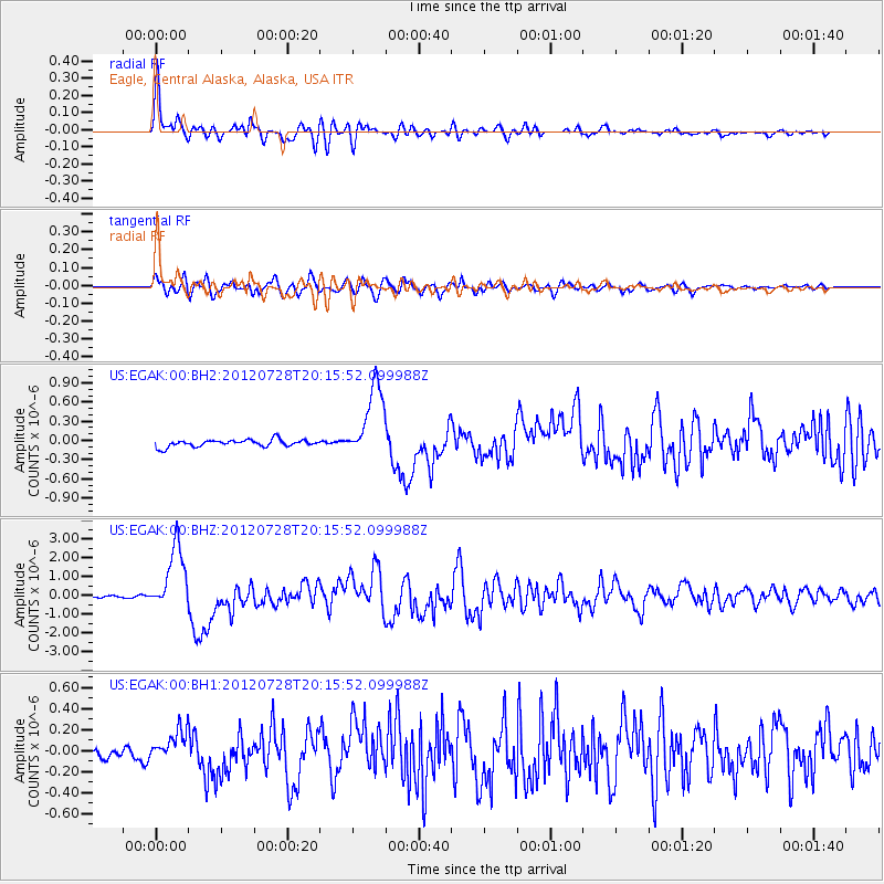
Signal To Noise
| Channel | StoN | STA | LTA |
| US:EGAK:00:BHZ:20120728T20:15:52.099988Z | 31.569551 | 1.7256687E-6 | 5.4662436E-8 |
| US:EGAK:00:BH1:20120728T20:15:52.099988Z | 1.8877454 | 1.3973641E-7 | 7.402291E-8 |
| US:EGAK:00:BH2:20120728T20:15:52.099988Z | 10.616977 | 5.854147E-7 | 5.513949E-8 |
| Arrivals |
| Ps | 3.4 SECOND |
| PpPs | 13 SECOND |
| PsPs/PpSs | 17 SECOND |


