You are here: Home > Network List > TO - Tectonic Observatory Stations List
> Station CC38 CCSE CC38 > Earthquake Result Viewer
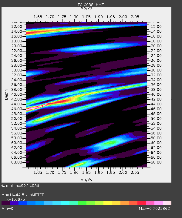
CC38 CCSE CC38 - Earthquake Result Viewer
| Earthquake location: |
Mariana Islands |
| Earthquake latitude/longitude: |
13.8/144.4 |
| Earthquake time(UTC): |
2014/09/17 (260) 06:14:46 GMT |
| Earthquake Depth: |
137 km |
| Earthquake Magnitude: |
6.7 MWC, 7.1 MI |
| Earthquake Catalog/Contributor: |
NEIC PDE/NEIC COMCAT |
|
| Network: |
TO Tectonic Observatory |
| Station: |
CC38 CCSE CC38 |
| Lat/Lon: |
36.38 N/118.84 W |
| Elevation: |
755 m |
|
| Distance: |
87.3 deg |
| Az: |
53.346 deg |
| Baz: |
284.983 deg |
| Ray Param: |
0.043131415 |
| Estimated Moho Depth: |
44.5 km |
| Estimated Crust Vp/Vs: |
1.67 |
| Assumed Crust Vp: |
6.291 km/s |
| Estimated Crust Vs: |
3.773 km/s |
| Estimated Crust Poisson's Ratio: |
0.22 |
|
| Radial Match: |
92.14036 % |
| Radial Bump: |
342 |
| Transverse Match: |
80.606544 % |
| Transverse Bump: |
400 |
| SOD ConfigId: |
3390531 |
| Insert Time: |
2019-04-14 02:31:03.475 +0000 |
| GWidth: |
2.5 |
| Max Bumps: |
400 |
| Tol: |
0.001 |
|

Signal To Noise
| Channel | StoN | STA | LTA |
| TO:CC38: :HHZ:20140917T06:26:45.21001Z | 93.54138 | 9.930389E-6 | 1.0616038E-7 |
| TO:CC38: :HHN:20140917T06:26:45.21001Z | 20.853418 | 1.7330796E-6 | 8.310769E-8 |
| TO:CC38: :HHE:20140917T06:26:45.21001Z | 67.23489 | 4.0070217E-6 | 5.9597355E-8 |
| Arrivals |
| Ps | 4.8 SECOND |
| PpPs | 18 SECOND |
| PsPs/PpSs | 23 SECOND |


