You are here: Home > Network List > XD14 - Illuminating the architecture of the greater Mount St. Helens magmatic systems f Stations List
> Station MG10 "Mount St Helens, WA" > Earthquake Result Viewer
MG10 "Mount St Helens, WA" - Earthquake Result Viewer
| Earthquake location: |
Mariana Islands |
| Earthquake latitude/longitude: |
13.8/144.4 |
| Earthquake time(UTC): |
2014/09/17 (260) 06:14:46 GMT |
| Earthquake Depth: |
137 km |
| Earthquake Magnitude: |
6.7 MWC, 7.1 MI |
| Earthquake Catalog/Contributor: |
NEIC PDE/NEIC COMCAT |
|
| Network: |
XD Illuminating the architecture of the greater Mount St. Helens magmatic systems f |
| Station: |
MG10 "Mount St Helens, WA" |
| Lat/Lon: |
46.34 N/121.66 W |
| Elevation: |
893 m |
|
| Distance: |
82.9 deg |
| Az: |
44.146 deg |
| Baz: |
282.33 deg |
| Ray Param: |
0.04627415 |
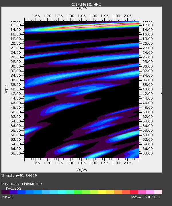
| Estimated Moho Depth: |
12.0 km |
| Estimated Crust Vp/Vs: |
1.90 |
| Assumed Crust Vp: |
6.597 km/s |
| Estimated Crust Vs: |
3.463 km/s |
| Estimated Crust Poisson's Ratio: |
0.31 |
|
| Radial Match: |
91.84659 % |
| Radial Bump: |
400 |
| Transverse Match: |
83.76054 % |
| Transverse Bump: |
400 |
| SOD ConfigId: |
3390531 |
| Insert Time: |
2019-04-14 02:31:46.534 +0000 |
| GWidth: |
2.5 |
| Max Bumps: |
400 |
| Tol: |
0.001 |
|

Signal To Noise
| Channel | StoN | STA | LTA |
| XD:MG10: :HHZ:20140917T06:26:23.254993Z | 53.65845 | 1.11909885E-5 | 2.0855965E-7 |
| XD:MG10: :HHN:20140917T06:26:23.254993Z | 5.5336795 | 6.9963977E-7 | 1.2643301E-7 |
| XD:MG10: :HHE:20140917T06:26:23.254993Z | 36.720284 | 4.543351E-6 | 1.2372865E-7 |
| Arrivals |
| Ps | 1.7 SECOND |
| PpPs | 5.2 SECOND |
| PsPs/PpSs | 6.8 SECOND |


