You are here: Home > Network List > XD14 - Illuminating the architecture of the greater Mount St. Helens magmatic systems f Stations List
> Station MH04 "Mount St Helens, WA" > Earthquake Result Viewer
MH04 "Mount St Helens, WA" - Earthquake Result Viewer
| Earthquake location: |
Mariana Islands |
| Earthquake latitude/longitude: |
13.8/144.4 |
| Earthquake time(UTC): |
2014/09/17 (260) 06:14:46 GMT |
| Earthquake Depth: |
137 km |
| Earthquake Magnitude: |
6.7 MWC, 7.1 MI |
| Earthquake Catalog/Contributor: |
NEIC PDE/NEIC COMCAT |
|
| Network: |
XD Illuminating the architecture of the greater Mount St. Helens magmatic systems f |
| Station: |
MH04 "Mount St Helens, WA" |
| Lat/Lon: |
46.28 N/122.43 W |
| Elevation: |
920 m |
|
| Distance: |
82.4 deg |
| Az: |
44.322 deg |
| Baz: |
281.798 deg |
| Ray Param: |
0.04662606 |
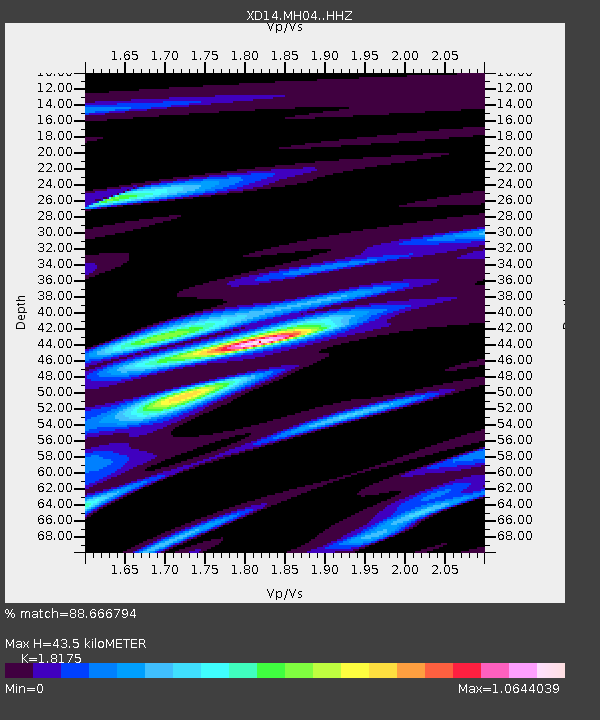
| Estimated Moho Depth: |
43.5 km |
| Estimated Crust Vp/Vs: |
1.82 |
| Assumed Crust Vp: |
6.566 km/s |
| Estimated Crust Vs: |
3.613 km/s |
| Estimated Crust Poisson's Ratio: |
0.28 |
|
| Radial Match: |
88.666794 % |
| Radial Bump: |
400 |
| Transverse Match: |
82.797844 % |
| Transverse Bump: |
400 |
| SOD ConfigId: |
3390531 |
| Insert Time: |
2019-04-14 02:31:48.665 +0000 |
| GWidth: |
2.5 |
| Max Bumps: |
400 |
| Tol: |
0.001 |
|

Signal To Noise
| Channel | StoN | STA | LTA |
| XD:MH04: :HHZ:20140917T06:26:20.629993Z | 40.952858 | 1.0220562E-5 | 2.4956896E-7 |
| XD:MH04: :HHN:20140917T06:26:20.629993Z | 5.6510134 | 8.7831614E-7 | 1.554263E-7 |
| XD:MH04: :HHE:20140917T06:26:20.629993Z | 9.541371 | 4.08066E-6 | 4.2768065E-7 |
| Arrivals |
| Ps | 5.6 SECOND |
| PpPs | 18 SECOND |
| PsPs/PpSs | 24 SECOND |


