You are here: Home > Network List > XD14 - Illuminating the architecture of the greater Mount St. Helens magmatic systems f Stations List
> Station MI07 "Mount St Helens, WA" > Earthquake Result Viewer
MI07 "Mount St Helens, WA" - Earthquake Result Viewer
| Earthquake location: |
Mariana Islands |
| Earthquake latitude/longitude: |
13.8/144.4 |
| Earthquake time(UTC): |
2014/09/17 (260) 06:14:46 GMT |
| Earthquake Depth: |
137 km |
| Earthquake Magnitude: |
6.7 MWC, 7.1 MI |
| Earthquake Catalog/Contributor: |
NEIC PDE/NEIC COMCAT |
|
| Network: |
XD Illuminating the architecture of the greater Mount St. Helens magmatic systems f |
| Station: |
MI07 "Mount St Helens, WA" |
| Lat/Lon: |
46.25 N/122.07 W |
| Elevation: |
1124 m |
|
| Distance: |
82.6 deg |
| Az: |
44.302 deg |
| Baz: |
282.05 deg |
| Ray Param: |
0.046455946 |
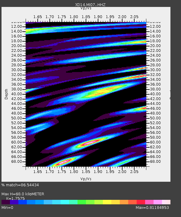
| Estimated Moho Depth: |
68.0 km |
| Estimated Crust Vp/Vs: |
1.76 |
| Assumed Crust Vp: |
6.566 km/s |
| Estimated Crust Vs: |
3.736 km/s |
| Estimated Crust Poisson's Ratio: |
0.26 |
|
| Radial Match: |
86.54434 % |
| Radial Bump: |
400 |
| Transverse Match: |
85.52174 % |
| Transverse Bump: |
400 |
| SOD ConfigId: |
3390531 |
| Insert Time: |
2019-04-14 02:31:53.714 +0000 |
| GWidth: |
2.5 |
| Max Bumps: |
400 |
| Tol: |
0.001 |
|

Signal To Noise
| Channel | StoN | STA | LTA |
| XD:MI07: :HHZ:20140917T06:26:21.905017Z | 57.501637 | 1.2178327E-5 | 2.1179096E-7 |
| XD:MI07: :HHN:20140917T06:26:21.905017Z | 7.3727994 | 1.6058345E-6 | 2.1780527E-7 |
| XD:MI07: :HHE:20140917T06:26:21.905017Z | 21.074379 | 4.055055E-6 | 1.9241635E-7 |
| Arrivals |
| Ps | 8.1 SECOND |
| PpPs | 28 SECOND |
| PsPs/PpSs | 36 SECOND |


