You are here: Home > Network List > XD14 - Illuminating the architecture of the greater Mount St. Helens magmatic systems f Stations List
> Station MK10 "Mount St Helens, WA" > Earthquake Result Viewer
MK10 "Mount St Helens, WA" - Earthquake Result Viewer
| Earthquake location: |
Mariana Islands |
| Earthquake latitude/longitude: |
13.8/144.4 |
| Earthquake time(UTC): |
2014/09/17 (260) 06:14:46 GMT |
| Earthquake Depth: |
137 km |
| Earthquake Magnitude: |
6.7 MWC, 7.1 MI |
| Earthquake Catalog/Contributor: |
NEIC PDE/NEIC COMCAT |
|
| Network: |
XD Illuminating the architecture of the greater Mount St. Helens magmatic systems f |
| Station: |
MK10 "Mount St Helens, WA" |
| Lat/Lon: |
46.14 N/121.77 W |
| Elevation: |
1186 m |
|
| Distance: |
82.8 deg |
| Az: |
44.36 deg |
| Baz: |
282.275 deg |
| Ray Param: |
0.046298306 |
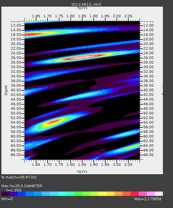
| Estimated Moho Depth: |
25.5 km |
| Estimated Crust Vp/Vs: |
1.86 |
| Assumed Crust Vp: |
6.597 km/s |
| Estimated Crust Vs: |
3.557 km/s |
| Estimated Crust Poisson's Ratio: |
0.30 |
|
| Radial Match: |
89.97301 % |
| Radial Bump: |
400 |
| Transverse Match: |
79.04563 % |
| Transverse Bump: |
400 |
| SOD ConfigId: |
3390531 |
| Insert Time: |
2019-04-14 02:32:03.546 +0000 |
| GWidth: |
2.5 |
| Max Bumps: |
400 |
| Tol: |
0.001 |
|

Signal To Noise
| Channel | StoN | STA | LTA |
| XD:MK10: :HHZ:20140917T06:26:23.080005Z | 64.26593 | 1.3533557E-5 | 2.1058679E-7 |
| XD:MK10: :HHN:20140917T06:26:23.080005Z | 5.552125 | 1.865624E-6 | 3.360198E-7 |
| XD:MK10: :HHE:20140917T06:26:23.080005Z | 14.781298 | 4.3715704E-6 | 2.957501E-7 |
| Arrivals |
| Ps | 3.4 SECOND |
| PpPs | 11 SECOND |
| PsPs/PpSs | 14 SECOND |


