You are here: Home > Network List > US - United States National Seismic Network Stations List
> Station WMOK Wichita Mountains, Oklahoma, USA > Earthquake Result Viewer
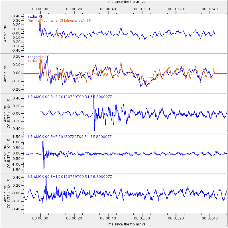
WMOK Wichita Mountains, Oklahoma, USA - Earthquake Result Viewer
*The percent match for this event was below the threshold and hence no stack was calculated.
| Earthquake location: |
Primor'ye, Russia |
| Earthquake latitude/longitude: |
47.4/139.1 |
| Earthquake time(UTC): |
2012/07/29 (211) 09:20:54 GMT |
| Earthquake Depth: |
502 km |
| Earthquake Magnitude: |
5.6 MB, 5.6 MW, 5.7 MW |
| Earthquake Catalog/Contributor: |
WHDF/NEIC |
|
| Network: |
US United States National Seismic Network |
| Station: |
WMOK Wichita Mountains, Oklahoma, USA |
| Lat/Lon: |
34.74 N/98.78 W |
| Elevation: |
486 m |
|
| Distance: |
83.2 deg |
| Az: |
44.606 deg |
| Baz: |
324.585 deg |
| Ray Param: |
$rayparam |
*The percent match for this event was below the threshold and hence was not used in the summary stack. |
|
| Radial Match: |
46.58884 % |
| Radial Bump: |
400 |
| Transverse Match: |
37.558926 % |
| Transverse Bump: |
400 |
| SOD ConfigId: |
558545 |
| Insert Time: |
2013-09-19 23:08:21.734 +0000 |
| GWidth: |
2.5 |
| Max Bumps: |
400 |
| Tol: |
0.001 |
|
Signal To Noise
| Channel | StoN | STA | LTA |
| US:WMOK:00:BHZ:20120729T09:31:56.800007Z | 8.940911 | 5.292895E-7 | 5.9198605E-8 |
| US:WMOK:00:BH1:20120729T09:31:56.800007Z | 2.702379 | 1.8468462E-7 | 6.834149E-8 |
| US:WMOK:00:BH2:20120729T09:31:56.800007Z | 4.6597056 | 1.7323315E-7 | 3.7176846E-8 |
| Arrivals |
| Ps | |
| PpPs | |
| PsPs/PpSs | |


