You are here: Home > Network List > US - United States National Seismic Network Stations List
> Station DGMT Dagmar, Montana, USA > Earthquake Result Viewer
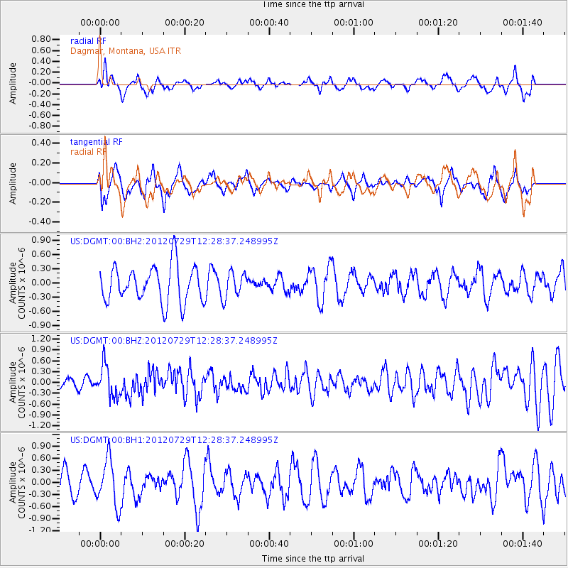
DGMT Dagmar, Montana, USA - Earthquake Result Viewer
*The percent match for this event was below the threshold and hence no stack was calculated.
| Earthquake location: |
Near Coast Of Chiapas, Mexico |
| Earthquake latitude/longitude: |
14.2/-92.3 |
| Earthquake time(UTC): |
2012/07/29 (211) 12:22:11 GMT |
| Earthquake Depth: |
18 km |
| Earthquake Magnitude: |
5.6 MB, 5.5 MS, 5.9 MW, 5.8 MW |
| Earthquake Catalog/Contributor: |
WHDF/NEIC |
|
| Network: |
US United States National Seismic Network |
| Station: |
DGMT Dagmar, Montana, USA |
| Lat/Lon: |
48.47 N/104.20 W |
| Elevation: |
0.0 m |
|
| Distance: |
35.6 deg |
| Az: |
346.353 deg |
| Baz: |
159.889 deg |
| Ray Param: |
$rayparam |
*The percent match for this event was below the threshold and hence was not used in the summary stack. |
|
| Radial Match: |
50.957172 % |
| Radial Bump: |
400 |
| Transverse Match: |
44.716698 % |
| Transverse Bump: |
387 |
| SOD ConfigId: |
558545 |
| Insert Time: |
2013-09-19 23:09:52.858 +0000 |
| GWidth: |
2.5 |
| Max Bumps: |
400 |
| Tol: |
0.001 |
|
Signal To Noise
| Channel | StoN | STA | LTA |
| US:DGMT:00:BHZ:20120729T12:28:37.248995Z | 2.6683595 | 4.466043E-7 | 1.6737036E-7 |
| US:DGMT:00:BH1:20120729T12:28:37.248995Z | 2.0907466 | 5.939054E-7 | 2.8406376E-7 |
| US:DGMT:00:BH2:20120729T12:28:37.248995Z | 0.6891522 | 2.6717237E-7 | 3.876827E-7 |
| Arrivals |
| Ps | |
| PpPs | |
| PsPs/PpSs | |


