You are here: Home > Network List > XL12 - Hangay Dome, Mongolia Stations List
> Station AT06 AT06 > Earthquake Result Viewer
AT06 AT06 - Earthquake Result Viewer
| Earthquake location: |
Mariana Islands |
| Earthquake latitude/longitude: |
13.8/144.4 |
| Earthquake time(UTC): |
2014/09/17 (260) 06:14:46 GMT |
| Earthquake Depth: |
137 km |
| Earthquake Magnitude: |
6.7 MWC, 7.1 MI |
| Earthquake Catalog/Contributor: |
NEIC PDE/NEIC COMCAT |
|
| Network: |
XL Hangay Dome, Mongolia |
| Station: |
AT06 AT06 |
| Lat/Lon: |
46.35 N/96.51 E |
| Elevation: |
2047 m |
|
| Distance: |
51.6 deg |
| Az: |
318.999 deg |
| Baz: |
113.024 deg |
| Ray Param: |
0.06687247 |
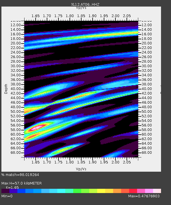
| Estimated Moho Depth: |
57.0 km |
| Estimated Crust Vp/Vs: |
1.65 |
| Assumed Crust Vp: |
6.642 km/s |
| Estimated Crust Vs: |
4.025 km/s |
| Estimated Crust Poisson's Ratio: |
0.21 |
|
| Radial Match: |
98.019264 % |
| Radial Bump: |
258 |
| Transverse Match: |
81.033775 % |
| Transverse Bump: |
400 |
| SOD ConfigId: |
3390531 |
| Insert Time: |
2019-04-14 02:32:26.063 +0000 |
| GWidth: |
2.5 |
| Max Bumps: |
400 |
| Tol: |
0.001 |
|

Signal To Noise
| Channel | StoN | STA | LTA |
| XL:AT06: :HHZ:20140917T06:23:07.059009Z | 155.89099 | 1.242702E-5 | 7.971608E-8 |
| XL:AT06: :HHN:20140917T06:23:07.059009Z | 27.153074 | 2.3685036E-6 | 8.7227825E-8 |
| XL:AT06: :HHE:20140917T06:23:07.059009Z | 73.593575 | 5.8876994E-6 | 8.00029E-8 |
| Arrivals |
| Ps | 5.9 SECOND |
| PpPs | 21 SECOND |
| PsPs/PpSs | 27 SECOND |


