You are here: Home > Network List > YB13 - Continental Dynamics/Cent. Anatolian Tectonics:Surface to Mantle Dynamics During Stations List
> Station AT13 Yazicepni,Yozgat,Turkey > Earthquake Result Viewer
AT13 Yazicepni,Yozgat,Turkey - Earthquake Result Viewer
| Earthquake location: |
Mariana Islands |
| Earthquake latitude/longitude: |
13.8/144.4 |
| Earthquake time(UTC): |
2014/09/17 (260) 06:14:46 GMT |
| Earthquake Depth: |
137 km |
| Earthquake Magnitude: |
6.7 MWC, 7.1 MI |
| Earthquake Catalog/Contributor: |
NEIC PDE/NEIC COMCAT |
|
| Network: |
YB Continental Dynamics/Cent. Anatolian Tectonics:Surface to Mantle Dynamics During |
| Station: |
AT13 Yazicepni,Yozgat,Turkey |
| Lat/Lon: |
39.08 N/35.32 E |
| Elevation: |
1254 m |
|
| Distance: |
95.7 deg |
| Az: |
312.335 deg |
| Baz: |
67.342 deg |
| Ray Param: |
0.040616687 |
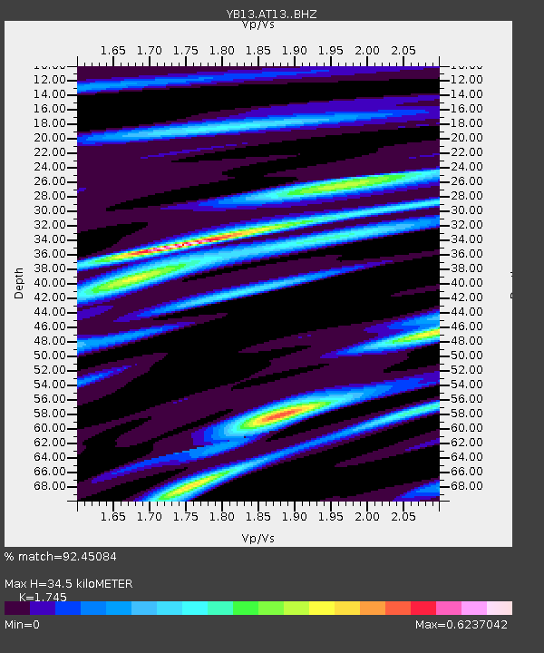
| Estimated Moho Depth: |
34.5 km |
| Estimated Crust Vp/Vs: |
1.75 |
| Assumed Crust Vp: |
6.35 km/s |
| Estimated Crust Vs: |
3.639 km/s |
| Estimated Crust Poisson's Ratio: |
0.26 |
|
| Radial Match: |
92.45084 % |
| Radial Bump: |
400 |
| Transverse Match: |
83.36708 % |
| Transverse Bump: |
400 |
| SOD ConfigId: |
3390531 |
| Insert Time: |
2019-04-14 02:33:01.068 +0000 |
| GWidth: |
2.5 |
| Max Bumps: |
400 |
| Tol: |
0.001 |
|

Signal To Noise
| Channel | StoN | STA | LTA |
| YB:AT13: :BHZ:20140917T06:27:24.400012Z | 40.33771 | 1.8374297E-6 | 4.5551165E-8 |
| YB:AT13: :BHN:20140917T06:27:24.400012Z | 5.0464206 | 2.9927975E-7 | 5.9305354E-8 |
| YB:AT13: :BHE:20140917T06:27:24.400012Z | 8.816824 | 4.296143E-7 | 4.872665E-8 |
| Arrivals |
| Ps | 4.1 SECOND |
| PpPs | 15 SECOND |
| PsPs/PpSs | 19 SECOND |


