You are here: Home > Network List > YB13 - Continental Dynamics/Cent. Anatolian Tectonics:Surface to Mantle Dynamics During Stations List
> Station AT28 Suleymanobasi,Gaziantep,Turkey > Earthquake Result Viewer
AT28 Suleymanobasi,Gaziantep,Turkey - Earthquake Result Viewer
| Earthquake location: |
Mariana Islands |
| Earthquake latitude/longitude: |
13.8/144.4 |
| Earthquake time(UTC): |
2014/09/17 (260) 06:14:46 GMT |
| Earthquake Depth: |
137 km |
| Earthquake Magnitude: |
6.7 MWC, 7.1 MI |
| Earthquake Catalog/Contributor: |
NEIC PDE/NEIC COMCAT |
|
| Network: |
YB Continental Dynamics/Cent. Anatolian Tectonics:Surface to Mantle Dynamics During |
| Station: |
AT28 Suleymanobasi,Gaziantep,Turkey |
| Lat/Lon: |
37.25 N/37.55 E |
| Elevation: |
839 m |
|
| Distance: |
94.7 deg |
| Az: |
309.979 deg |
| Baz: |
68.931 deg |
| Ray Param: |
0.040870085 |
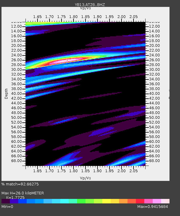
| Estimated Moho Depth: |
26.0 km |
| Estimated Crust Vp/Vs: |
1.77 |
| Assumed Crust Vp: |
6.247 km/s |
| Estimated Crust Vs: |
3.524 km/s |
| Estimated Crust Poisson's Ratio: |
0.27 |
|
| Radial Match: |
92.66275 % |
| Radial Bump: |
400 |
| Transverse Match: |
78.21972 % |
| Transverse Bump: |
400 |
| SOD ConfigId: |
3390531 |
| Insert Time: |
2019-04-14 02:33:09.280 +0000 |
| GWidth: |
2.5 |
| Max Bumps: |
400 |
| Tol: |
0.001 |
|

Signal To Noise
| Channel | StoN | STA | LTA |
| YB:AT28: :BHZ:20140917T06:27:20.100024Z | 29.05015 | 1.982595E-6 | 6.8247324E-8 |
| YB:AT28: :BHN:20140917T06:27:20.100024Z | 4.0214386 | 2.2764566E-7 | 5.6608012E-8 |
| YB:AT28: :BHE:20140917T06:27:20.100024Z | 7.346634 | 5.838795E-7 | 7.947578E-8 |
| Arrivals |
| Ps | 3.3 SECOND |
| PpPs | 11 SECOND |
| PsPs/PpSs | 15 SECOND |


