You are here: Home > Network List > ZJ12 - Transantarctic Mountains Northern Network Stations List
> Station APRL East Antarctica > Earthquake Result Viewer
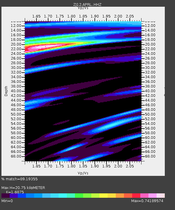
APRL East Antarctica - Earthquake Result Viewer
| Earthquake location: |
Mariana Islands |
| Earthquake latitude/longitude: |
13.8/144.4 |
| Earthquake time(UTC): |
2014/09/17 (260) 06:14:46 GMT |
| Earthquake Depth: |
137 km |
| Earthquake Magnitude: |
6.7 MWC, 7.1 MI |
| Earthquake Catalog/Contributor: |
NEIC PDE/NEIC COMCAT |
|
| Network: |
ZJ Transantarctic Mountains Northern Network |
| Station: |
APRL East Antarctica |
| Lat/Lon: |
73.19 S/158.70 E |
| Elevation: |
2258 m |
|
| Distance: |
87.3 deg |
| Az: |
175.873 deg |
| Baz: |
346.091 deg |
| Ray Param: |
0.043157462 |
| Estimated Moho Depth: |
20.75 km |
| Estimated Crust Vp/Vs: |
1.69 |
| Assumed Crust Vp: |
6.306 km/s |
| Estimated Crust Vs: |
3.737 km/s |
| Estimated Crust Poisson's Ratio: |
0.23 |
|
| Radial Match: |
89.19355 % |
| Radial Bump: |
400 |
| Transverse Match: |
90.341545 % |
| Transverse Bump: |
367 |
| SOD ConfigId: |
3390531 |
| Insert Time: |
2019-04-14 02:33:51.145 +0000 |
| GWidth: |
2.5 |
| Max Bumps: |
400 |
| Tol: |
0.001 |
|

Signal To Noise
| Channel | StoN | STA | LTA |
| ZJ:APRL: :HHZ:20140917T06:26:45.780017Z | 51.88439 | 8.232458E-6 | 1.5866925E-7 |
| ZJ:APRL: :HHN:20140917T06:26:45.780017Z | 12.33449 | 1.2189566E-6 | 9.8825055E-8 |
| ZJ:APRL: :HHE:20140917T06:26:45.780017Z | 11.252608 | 9.827593E-7 | 8.7336126E-8 |
| Arrivals |
| Ps | 2.3 SECOND |
| PpPs | 8.6 SECOND |
| PsPs/PpSs | 11 SECOND |


