You are here: Home > Network List > IU - Global Seismograph Network (GSN - IRIS/USGS) Stations List
> Station CTAO Charters Towers, Australia > Earthquake Result Viewer
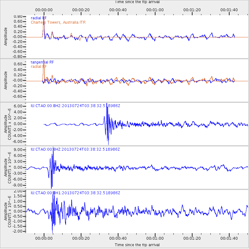
CTAO Charters Towers, Australia - Earthquake Result Viewer
*The percent match for this event was below the threshold and hence no stack was calculated.
| Earthquake location: |
South Of Fiji Islands |
| Earthquake latitude/longitude: |
-23.1/-177.2 |
| Earthquake time(UTC): |
2013/07/24 (205) 03:32:33 GMT |
| Earthquake Depth: |
156 km |
| Earthquake Magnitude: |
5.9 MW, 5.5 MB, 5.9 MW |
| Earthquake Catalog/Contributor: |
NEIC PDE/NEIC PDE-W |
|
| Network: |
IU Global Seismograph Network (GSN - IRIS/USGS) |
| Station: |
CTAO Charters Towers, Australia |
| Lat/Lon: |
20.09 S/146.25 E |
| Elevation: |
357 m |
|
| Distance: |
34.0 deg |
| Az: |
268.028 deg |
| Baz: |
101.811 deg |
| Ray Param: |
$rayparam |
*The percent match for this event was below the threshold and hence was not used in the summary stack. |
|
| Radial Match: |
75.24175 % |
| Radial Bump: |
398 |
| Transverse Match: |
60.571095 % |
| Transverse Bump: |
400 |
| SOD ConfigId: |
589702 |
| Insert Time: |
2013-09-20 03:13:27.703 +0000 |
| GWidth: |
2.5 |
| Max Bumps: |
400 |
| Tol: |
0.001 |
|
Signal To Noise
| Channel | StoN | STA | LTA |
| IU:CTAO:00:BHZ:20130724T03:38:32.518986Z | 10.7109585 | 3.2187106E-6 | 3.0050631E-7 |
| IU:CTAO:00:BH1:20130724T03:38:32.518986Z | 3.211826 | 5.3855996E-7 | 1.6768031E-7 |
| IU:CTAO:00:BH2:20130724T03:38:32.518986Z | 9.627701 | 2.0969583E-6 | 2.1780467E-7 |
| Arrivals |
| Ps | |
| PpPs | |
| PsPs/PpSs | |


