You are here: Home > Network List > TA - USArray Transportable Network (new EarthScope stations) Stations List
> Station H17A Grant Village (NPS), Yellowstone Nt. Park, WY, USA > Earthquake Result Viewer
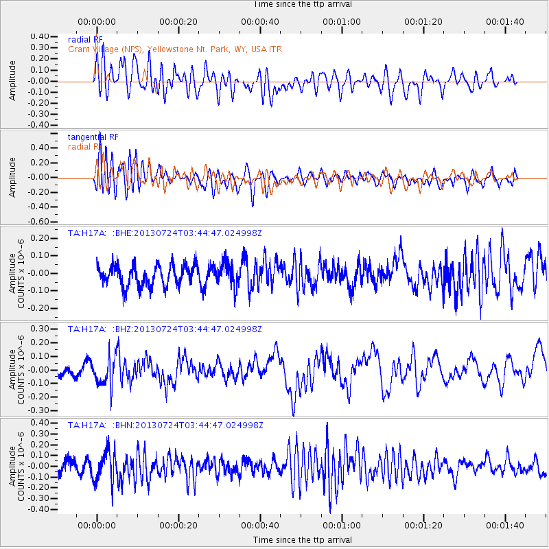
H17A Grant Village (NPS), Yellowstone Nt. Park, WY, USA - Earthquake Result Viewer
*The percent match for this event was below the threshold and hence no stack was calculated.
| Earthquake location: |
South Of Fiji Islands |
| Earthquake latitude/longitude: |
-23.1/-177.2 |
| Earthquake time(UTC): |
2013/07/24 (205) 03:32:33 GMT |
| Earthquake Depth: |
156 km |
| Earthquake Magnitude: |
5.9 MW, 5.5 MB, 5.9 MW |
| Earthquake Catalog/Contributor: |
NEIC PDE/NEIC PDE-W |
|
| Network: |
TA USArray Transportable Network (new EarthScope stations) |
| Station: |
H17A Grant Village (NPS), Yellowstone Nt. Park, WY, USA |
| Lat/Lon: |
44.40 N/110.58 W |
| Elevation: |
2400 m |
|
| Distance: |
90.6 deg |
| Az: |
41.161 deg |
| Baz: |
237.691 deg |
| Ray Param: |
$rayparam |
*The percent match for this event was below the threshold and hence was not used in the summary stack. |
|
| Radial Match: |
50.304493 % |
| Radial Bump: |
400 |
| Transverse Match: |
67.405235 % |
| Transverse Bump: |
400 |
| SOD ConfigId: |
589702 |
| Insert Time: |
2013-09-20 03:17:35.953 +0000 |
| GWidth: |
2.5 |
| Max Bumps: |
400 |
| Tol: |
0.001 |
|
Signal To Noise
| Channel | StoN | STA | LTA |
| TA:H17A: :BHZ:20130724T03:44:47.024998Z | 1.6147658 | 1.0372536E-7 | 6.423554E-8 |
| TA:H17A: :BHN:20130724T03:44:47.024998Z | 2.6204941 | 1.4530318E-7 | 5.544877E-8 |
| TA:H17A: :BHE:20130724T03:44:47.024998Z | 1.1451801 | 6.6187916E-8 | 5.7796953E-8 |
| Arrivals |
| Ps | |
| PpPs | |
| PsPs/PpSs | |


