You are here: Home > Network List > TA - USArray Transportable Network (new EarthScope stations) Stations List
> Station L04D Klamath Falls, OR, USA > Earthquake Result Viewer
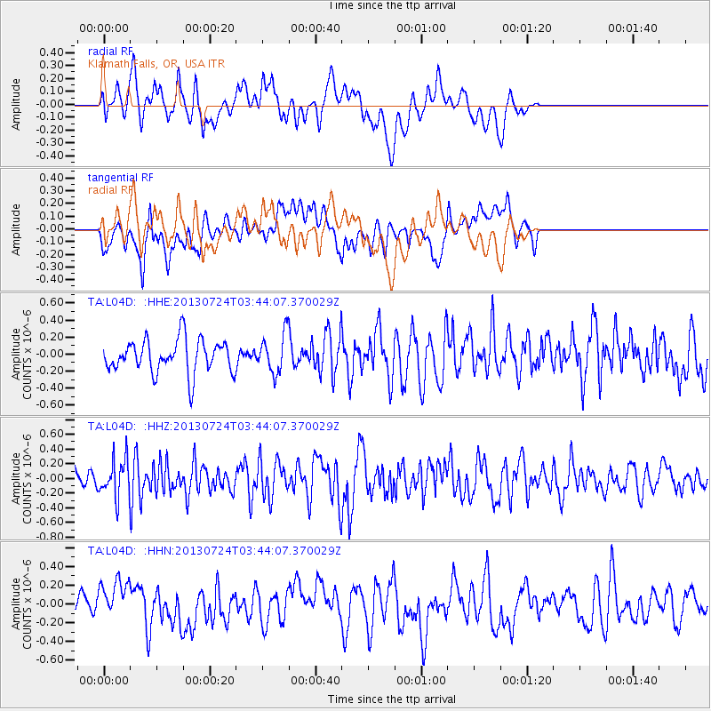
L04D Klamath Falls, OR, USA - Earthquake Result Viewer
*The percent match for this event was below the threshold and hence no stack was calculated.
| Earthquake location: |
South Of Fiji Islands |
| Earthquake latitude/longitude: |
-23.1/-177.2 |
| Earthquake time(UTC): |
2013/07/24 (205) 03:32:33 GMT |
| Earthquake Depth: |
156 km |
| Earthquake Magnitude: |
5.9 MW, 5.5 MB, 5.9 MW |
| Earthquake Catalog/Contributor: |
NEIC PDE/NEIC PDE-W |
|
| Network: |
TA USArray Transportable Network (new EarthScope stations) |
| Station: |
L04D Klamath Falls, OR, USA |
| Lat/Lon: |
42.22 N/122.30 W |
| Elevation: |
1437 m |
|
| Distance: |
82.4 deg |
| Az: |
37.822 deg |
| Baz: |
229.456 deg |
| Ray Param: |
$rayparam |
*The percent match for this event was below the threshold and hence was not used in the summary stack. |
|
| Radial Match: |
57.27001 % |
| Radial Bump: |
400 |
| Transverse Match: |
57.034386 % |
| Transverse Bump: |
400 |
| SOD ConfigId: |
589702 |
| Insert Time: |
2013-09-20 03:18:03.539 +0000 |
| GWidth: |
2.5 |
| Max Bumps: |
400 |
| Tol: |
0.001 |
|
Signal To Noise
| Channel | StoN | STA | LTA |
| TA:L04D: :HHZ:20130724T03:44:07.370029Z | 2.093041 | 2.5337582E-7 | 1.2105632E-7 |
| TA:L04D: :HHN:20130724T03:44:07.370029Z | 1.4533305 | 2.6386417E-7 | 1.8155825E-7 |
| TA:L04D: :HHE:20130724T03:44:07.370029Z | 1.1587209 | 2.2512533E-7 | 1.9428781E-7 |
| Arrivals |
| Ps | |
| PpPs | |
| PsPs/PpSs | |


