You are here: Home > Network List > KN - Kyrgyz Seismic Telemetry Network Stations List
> Station TKM2 - > Earthquake Result Viewer
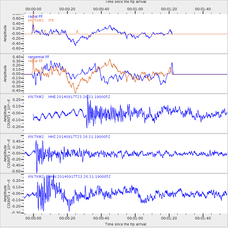
TKM2 - - Earthquake Result Viewer
*The percent match for this event was below the threshold and hence no stack was calculated.
| Earthquake location: |
Southwestern Ryukyu Isl., Japan |
| Earthquake latitude/longitude: |
24.8/125.4 |
| Earthquake time(UTC): |
2014/09/17 (260) 23:18:55 GMT |
| Earthquake Depth: |
45 km |
| Earthquake Magnitude: |
5.0 MW |
| Earthquake Catalog/Contributor: |
ISC/ISC |
|
| Network: |
KN Kyrgyz Seismic Telemetry Network |
| Station: |
TKM2 - |
| Lat/Lon: |
42.92 N/75.60 E |
| Elevation: |
2020 m |
|
| Distance: |
44.4 deg |
| Az: |
306.716 deg |
| Baz: |
97.478 deg |
| Ray Param: |
$rayparam |
*The percent match for this event was below the threshold and hence was not used in the summary stack. |
|
| Radial Match: |
73.54936 % |
| Radial Bump: |
400 |
| Transverse Match: |
34.278034 % |
| Transverse Bump: |
400 |
| SOD ConfigId: |
3390531 |
| Insert Time: |
2019-04-14 02:37:27.273 +0000 |
| GWidth: |
2.5 |
| Max Bumps: |
400 |
| Tol: |
0.001 |
|
Signal To Noise
| Channel | StoN | STA | LTA |
| KN:TKM2: :HHZ:20140917T23:26:31.190005Z | 6.1731663 | 2.2377654E-7 | 3.624988E-8 |
| KN:TKM2: :HHN:20140917T23:26:31.190005Z | 3.076946 | 8.990229E-8 | 2.9218027E-8 |
| KN:TKM2: :HHE:20140917T23:26:31.190005Z | 2.84629 | 1.09994396E-7 | 3.864483E-8 |
| Arrivals |
| Ps | |
| PpPs | |
| PsPs/PpSs | |


