You are here: Home > Network List > UW - Pacific Northwest Regional Seismic Network Stations List
> Station LEBA Lebam, WA, USA > Earthquake Result Viewer
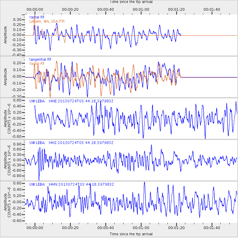
LEBA Lebam, WA, USA - Earthquake Result Viewer
*The percent match for this event was below the threshold and hence no stack was calculated.
| Earthquake location: |
South Of Fiji Islands |
| Earthquake latitude/longitude: |
-23.1/-177.2 |
| Earthquake time(UTC): |
2013/07/24 (205) 03:32:33 GMT |
| Earthquake Depth: |
156 km |
| Earthquake Magnitude: |
5.9 MW, 5.5 MB, 5.9 MW |
| Earthquake Catalog/Contributor: |
NEIC PDE/NEIC PDE-W |
|
| Network: |
UW Pacific Northwest Regional Seismic Network |
| Station: |
LEBA Lebam, WA, USA |
| Lat/Lon: |
46.55 N/123.56 W |
| Elevation: |
73 m |
|
| Distance: |
84.6 deg |
| Az: |
33.947 deg |
| Baz: |
228.141 deg |
| Ray Param: |
$rayparam |
*The percent match for this event was below the threshold and hence was not used in the summary stack. |
|
| Radial Match: |
49.961727 % |
| Radial Bump: |
400 |
| Transverse Match: |
46.336056 % |
| Transverse Bump: |
400 |
| SOD ConfigId: |
589702 |
| Insert Time: |
2013-09-20 03:21:08.758 +0000 |
| GWidth: |
2.5 |
| Max Bumps: |
400 |
| Tol: |
0.001 |
|
Signal To Noise
| Channel | StoN | STA | LTA |
| UW:LEBA: :HHZ:20130724T03:44:18.397983Z | 3.266907 | 4.1323608E-7 | 1.2649153E-7 |
| UW:LEBA: :HHN:20130724T03:44:18.397983Z | 1.1749319 | 1.6956398E-7 | 1.4431814E-7 |
| UW:LEBA: :HHE:20130724T03:44:18.397983Z | 1.6257565 | 2.4772112E-7 | 1.5237282E-7 |
| Arrivals |
| Ps | |
| PpPs | |
| PsPs/PpSs | |


