You are here: Home > Network List > TA - USArray Transportable Network (new EarthScope stations) Stations List
> Station O03E Paynes Creek, CA, USA > Earthquake Result Viewer
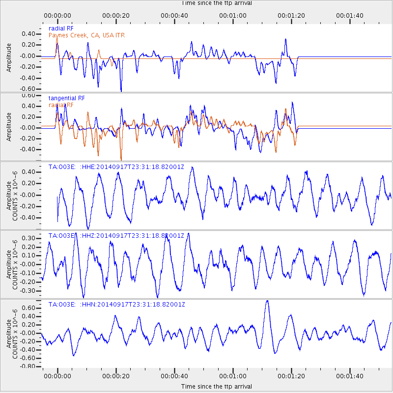
O03E Paynes Creek, CA, USA - Earthquake Result Viewer
*The percent match for this event was below the threshold and hence no stack was calculated.
| Earthquake location: |
Southwestern Ryukyu Isl., Japan |
| Earthquake latitude/longitude: |
24.8/125.4 |
| Earthquake time(UTC): |
2014/09/17 (260) 23:18:55 GMT |
| Earthquake Depth: |
45 km |
| Earthquake Magnitude: |
5.0 MW |
| Earthquake Catalog/Contributor: |
ISC/ISC |
|
| Network: |
TA USArray Transportable Network (new EarthScope stations) |
| Station: |
O03E Paynes Creek, CA, USA |
| Lat/Lon: |
40.29 N/121.80 W |
| Elevation: |
967 m |
|
| Distance: |
90.0 deg |
| Az: |
44.837 deg |
| Baz: |
303.114 deg |
| Ray Param: |
$rayparam |
*The percent match for this event was below the threshold and hence was not used in the summary stack. |
|
| Radial Match: |
57.5148 % |
| Radial Bump: |
400 |
| Transverse Match: |
48.911854 % |
| Transverse Bump: |
400 |
| SOD ConfigId: |
3390531 |
| Insert Time: |
2019-04-14 02:38:44.133 +0000 |
| GWidth: |
2.5 |
| Max Bumps: |
400 |
| Tol: |
0.001 |
|
Signal To Noise
| Channel | StoN | STA | LTA |
| TA:O03E: :HHZ:20140917T23:31:18.82001Z | 1.0394999 | 1.210417E-7 | 1.16442244E-7 |
| TA:O03E: :HHN:20140917T23:31:18.82001Z | 1.3000584 | 2.2023677E-7 | 1.694053E-7 |
| TA:O03E: :HHE:20140917T23:31:18.82001Z | 0.46644425 | 1.2998728E-7 | 2.7867702E-7 |
| Arrivals |
| Ps | |
| PpPs | |
| PsPs/PpSs | |


