You are here: Home > Network List > AT - Alaska Tsunami Warning Seismic System Stations List
> Station PMR Palmer, Alaska > Earthquake Result Viewer
PMR Palmer, Alaska - Earthquake Result Viewer
| Earthquake location: |
Vanuatu Islands |
| Earthquake latitude/longitude: |
-15.4/167.7 |
| Earthquake time(UTC): |
2013/07/26 (207) 07:07:15 GMT |
| Earthquake Depth: |
124 km |
| Earthquake Magnitude: |
6.1 MW, 6.1 MW |
| Earthquake Catalog/Contributor: |
NEIC PDE/NEIC PDE-W |
|
| Network: |
AT Alaska Tsunami Warning Seismic System |
| Station: |
PMR Palmer, Alaska |
| Lat/Lon: |
61.59 N/149.13 W |
| Elevation: |
100 m |
|
| Distance: |
84.0 deg |
| Az: |
19.212 deg |
| Baz: |
221.588 deg |
| Ray Param: |
0.04553378 |
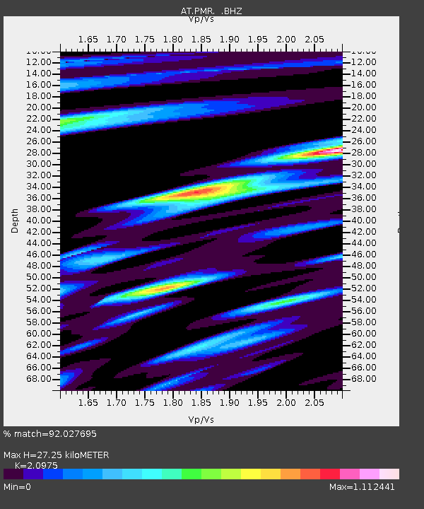
| Estimated Moho Depth: |
27.25 km |
| Estimated Crust Vp/Vs: |
2.10 |
| Assumed Crust Vp: |
6.566 km/s |
| Estimated Crust Vs: |
3.13 km/s |
| Estimated Crust Poisson's Ratio: |
0.35 |
|
| Radial Match: |
92.027695 % |
| Radial Bump: |
388 |
| Transverse Match: |
80.96321 % |
| Transverse Bump: |
400 |
| SOD ConfigId: |
589702 |
| Insert Time: |
2013-09-20 03:26:16.396 +0000 |
| GWidth: |
2.5 |
| Max Bumps: |
400 |
| Tol: |
0.001 |
|

Signal To Noise
| Channel | StoN | STA | LTA |
| AT:PMR: :BHZ:20130726T07:19:00.880Z | 8.615758 | 4.805643E-7 | 5.577737E-8 |
| AT:PMR: :BHN:20130726T07:19:00.880Z | 2.7272336 | 1.2670057E-7 | 4.645754E-8 |
| AT:PMR: :BHE:20130726T07:19:00.880Z | 4.933225 | 2.0130202E-7 | 4.0805357E-8 |
| Arrivals |
| Ps | 4.7 SECOND |
| PpPs | 13 SECOND |
| PsPs/PpSs | 17 SECOND |


