You are here: Home > Network List > CB - China National Seismic Network Stations List
> Station XLT Xilinhaote,Neimeng Province > Earthquake Result Viewer
XLT Xilinhaote,Neimeng Province - Earthquake Result Viewer
| Earthquake location: |
Vanuatu Islands |
| Earthquake latitude/longitude: |
-15.4/167.7 |
| Earthquake time(UTC): |
2013/07/26 (207) 07:07:15 GMT |
| Earthquake Depth: |
124 km |
| Earthquake Magnitude: |
6.1 MW, 6.1 MW |
| Earthquake Catalog/Contributor: |
NEIC PDE/NEIC PDE-W |
|
| Network: |
CB China National Seismic Network |
| Station: |
XLT Xilinhaote,Neimeng Province |
| Lat/Lon: |
43.90 N/116.08 E |
| Elevation: |
1030 m |
|
| Distance: |
75.5 deg |
| Az: |
324.175 deg |
| Baz: |
128.64 deg |
| Ray Param: |
0.0513454 |
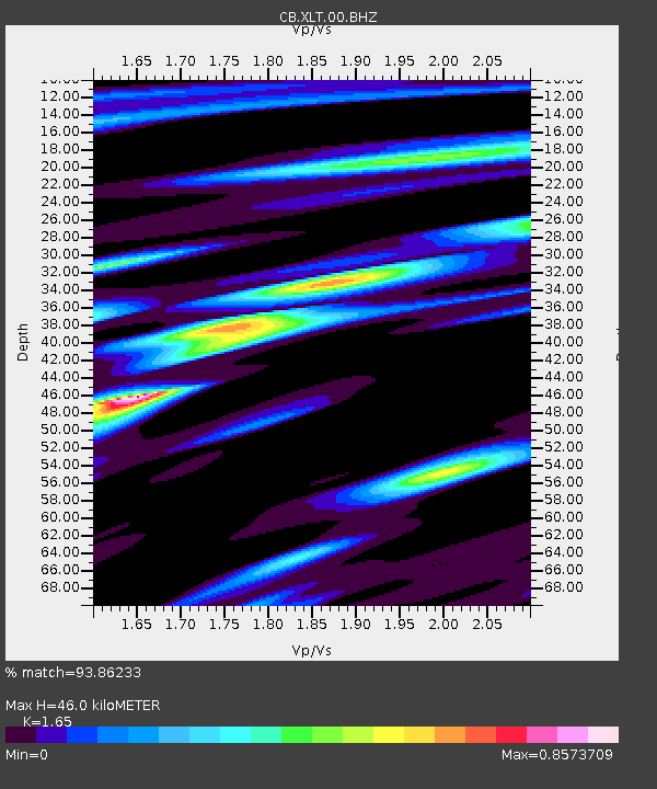
| Estimated Moho Depth: |
46.0 km |
| Estimated Crust Vp/Vs: |
1.65 |
| Assumed Crust Vp: |
6.459 km/s |
| Estimated Crust Vs: |
3.915 km/s |
| Estimated Crust Poisson's Ratio: |
0.21 |
|
| Radial Match: |
93.86233 % |
| Radial Bump: |
232 |
| Transverse Match: |
77.53571 % |
| Transverse Bump: |
335 |
| SOD ConfigId: |
589702 |
| Insert Time: |
2013-09-20 03:29:11.918 +0000 |
| GWidth: |
2.5 |
| Max Bumps: |
400 |
| Tol: |
0.001 |
|

Signal To Noise
| Channel | StoN | STA | LTA |
| CB:XLT:00:BHZ:20130726T07:18:15.15002Z | 10.824501 | 1.1270135E-6 | 1.0411691E-7 |
| CB:XLT:00:BHN:20130726T07:18:15.15002Z | 3.4329298 | 3.407955E-7 | 9.92725E-8 |
| CB:XLT:00:BHE:20130726T07:18:15.15002Z | 4.6150374 | 4.2477635E-7 | 9.20418E-8 |
| Arrivals |
| Ps | 4.8 SECOND |
| PpPs | 18 SECOND |
| PsPs/PpSs | 23 SECOND |


