You are here: Home > Network List > TA - USArray Transportable Network (new EarthScope stations) Stations List
> Station 121A Cookes Peak, Deming, NM, USA > Earthquake Result Viewer
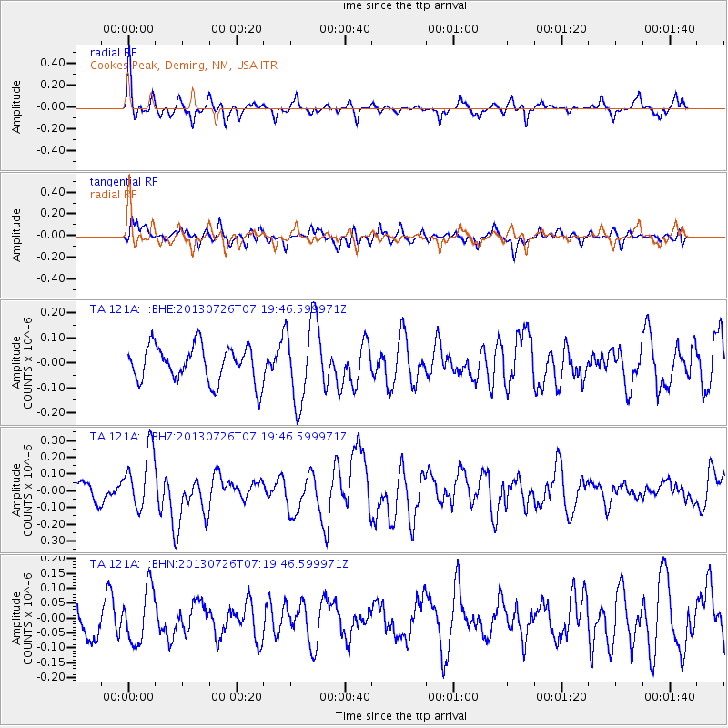
121A Cookes Peak, Deming, NM, USA - Earthquake Result Viewer
*The percent match for this event was below the threshold and hence no stack was calculated.
| Earthquake location: |
Vanuatu Islands |
| Earthquake latitude/longitude: |
-15.4/167.7 |
| Earthquake time(UTC): |
2013/07/26 (207) 07:07:15 GMT |
| Earthquake Depth: |
124 km |
| Earthquake Magnitude: |
6.1 MW, 6.1 MW |
| Earthquake Catalog/Contributor: |
NEIC PDE/NEIC PDE-W |
|
| Network: |
TA USArray Transportable Network (new EarthScope stations) |
| Station: |
121A Cookes Peak, Deming, NM, USA |
| Lat/Lon: |
32.53 N/107.79 W |
| Elevation: |
1652 m |
|
| Distance: |
93.6 deg |
| Az: |
57.411 deg |
| Baz: |
254.191 deg |
| Ray Param: |
$rayparam |
*The percent match for this event was below the threshold and hence was not used in the summary stack. |
|
| Radial Match: |
68.88801 % |
| Radial Bump: |
342 |
| Transverse Match: |
54.73895 % |
| Transverse Bump: |
400 |
| SOD ConfigId: |
589702 |
| Insert Time: |
2013-09-20 03:37:03.284 +0000 |
| GWidth: |
2.5 |
| Max Bumps: |
400 |
| Tol: |
0.001 |
|
Signal To Noise
| Channel | StoN | STA | LTA |
| TA:121A: :BHZ:20130726T07:19:46.599971Z | 2.0987222 | 1.8269388E-7 | 8.7050054E-8 |
| TA:121A: :BHN:20130726T07:19:46.599971Z | 1.2860168 | 9.246121E-8 | 7.1897354E-8 |
| TA:121A: :BHE:20130726T07:19:46.599971Z | 2.299676 | 1.6753198E-7 | 7.2850256E-8 |
| Arrivals |
| Ps | |
| PpPs | |
| PsPs/PpSs | |


