You are here: Home > Network List > US - United States National Seismic Network Stations List
> Station MSO Missoula, Montana, USA > Earthquake Result Viewer
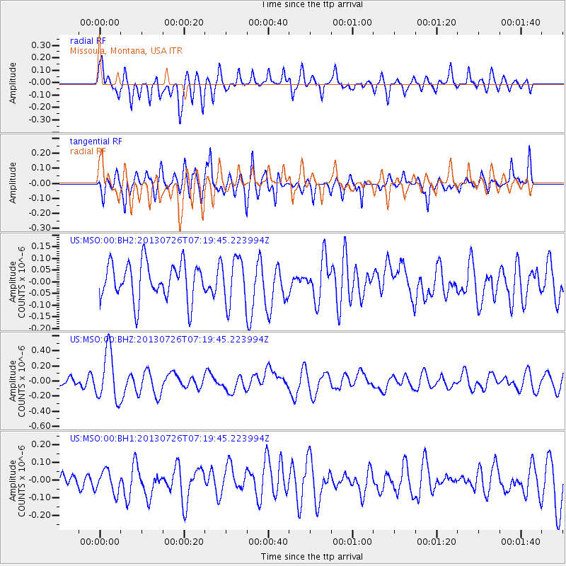
MSO Missoula, Montana, USA - Earthquake Result Viewer
*The percent match for this event was below the threshold and hence no stack was calculated.
| Earthquake location: |
Vanuatu Islands |
| Earthquake latitude/longitude: |
-15.4/167.7 |
| Earthquake time(UTC): |
2013/07/26 (207) 07:07:15 GMT |
| Earthquake Depth: |
124 km |
| Earthquake Magnitude: |
6.1 MW, 6.1 MW |
| Earthquake Catalog/Contributor: |
NEIC PDE/NEIC PDE-W |
|
| Network: |
US United States National Seismic Network |
| Station: |
MSO Missoula, Montana, USA |
| Lat/Lon: |
46.83 N/113.94 W |
| Elevation: |
1264 m |
|
| Distance: |
93.3 deg |
| Az: |
42.35 deg |
| Baz: |
251.163 deg |
| Ray Param: |
$rayparam |
*The percent match for this event was below the threshold and hence was not used in the summary stack. |
|
| Radial Match: |
66.36468 % |
| Radial Bump: |
400 |
| Transverse Match: |
52.443775 % |
| Transverse Bump: |
400 |
| SOD ConfigId: |
589702 |
| Insert Time: |
2013-09-20 03:39:26.269 +0000 |
| GWidth: |
2.5 |
| Max Bumps: |
400 |
| Tol: |
0.001 |
|
Signal To Noise
| Channel | StoN | STA | LTA |
| US:MSO:00:BHZ:20130726T07:19:45.223994Z | 5.961771 | 3.36432E-7 | 5.6431556E-8 |
| US:MSO:00:BH1:20130726T07:19:45.223994Z | 1.441488 | 6.3515245E-8 | 4.406228E-8 |
| US:MSO:00:BH2:20130726T07:19:45.223994Z | 1.2498306 | 9.835079E-8 | 7.869129E-8 |
| Arrivals |
| Ps | |
| PpPs | |
| PsPs/PpSs | |


