You are here: Home > Network List > AV - Alaska Volcano Observatory Stations List
> Station SPCR Ckakachatna River, Mount Spurr, Alaska > Earthquake Result Viewer
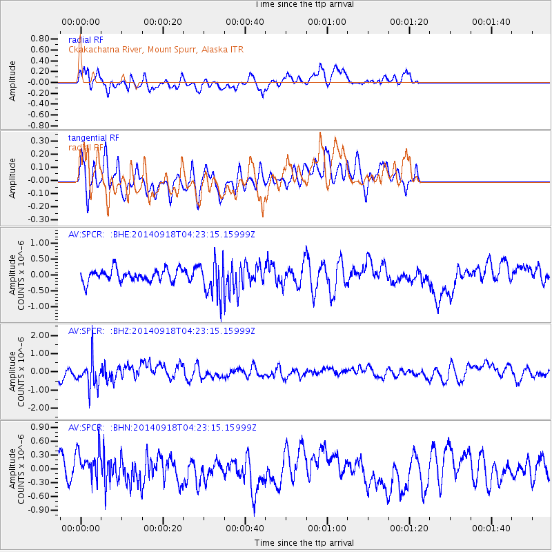
SPCR Ckakachatna River, Mount Spurr, Alaska - Earthquake Result Viewer
*The percent match for this event was below the threshold and hence no stack was calculated.
| Earthquake location: |
Northwest Of Kuril Islands |
| Earthquake latitude/longitude: |
50.6/150.2 |
| Earthquake time(UTC): |
2014/09/18 (261) 04:17:53 GMT |
| Earthquake Depth: |
502 km |
| Earthquake Magnitude: |
5.6 MW |
| Earthquake Catalog/Contributor: |
ISC/ISC |
|
| Network: |
AV Alaska Volcano Observatory |
| Station: |
SPCR Ckakachatna River, Mount Spurr, Alaska |
| Lat/Lon: |
61.20 N/152.21 W |
| Elevation: |
984 m |
|
| Distance: |
32.9 deg |
| Az: |
48.789 deg |
| Baz: |
277.847 deg |
| Ray Param: |
$rayparam |
*The percent match for this event was below the threshold and hence was not used in the summary stack. |
|
| Radial Match: |
64.81172 % |
| Radial Bump: |
400 |
| Transverse Match: |
58.958347 % |
| Transverse Bump: |
400 |
| SOD ConfigId: |
3390531 |
| Insert Time: |
2019-04-14 02:43:05.852 +0000 |
| GWidth: |
2.5 |
| Max Bumps: |
400 |
| Tol: |
0.001 |
|
Signal To Noise
| Channel | StoN | STA | LTA |
| AV:SPCR: :BHZ:20140918T04:23:15.15999Z | 2.7243009 | 8.026006E-7 | 2.9460793E-7 |
| AV:SPCR: :BHN:20140918T04:23:15.15999Z | 1.495041 | 3.538812E-7 | 2.3670336E-7 |
| AV:SPCR: :BHE:20140918T04:23:15.15999Z | 2.9780703 | 5.6908374E-7 | 1.9109146E-7 |
| Arrivals |
| Ps | |
| PpPs | |
| PsPs/PpSs | |


