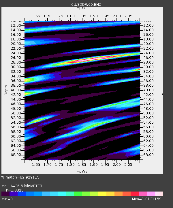
SDDR Presa de Sabaneta, Dominican Republic - Earthquake Result Viewer

Earthquake location: South Sandwich Islands Region
Earthquake latitude/longitude: -57.9/-23.8
Earthquake time(UTC): 2013/07/26 (207) 21:32:59 GMT
Earthquake Depth: 13 km
Earthquake Magnitude: 6.2 MW, 6.0 MS, 6.2 MB, 6.3 MW
Earthquake Catalog/Contributor: NEIC PDE/NEIC PDE-W
Network: CU Caribbean Network (USGS)
Station: SDDR Presa de Sabaneta, Dominican Republic
Lat/Lon: 18.98 N/71.29 W
Elevation: 589 m
Distance: 86.1 deg
Az: 315.677 deg
Baz: 156.79 deg
Ray Param: 0.04429215
Estimated Moho Depth: 26.5 km
Estimated Crust Vp/Vs: 1.88
Assumed Crust Vp: 6.448 km/s
Estimated Crust Vs: 3.425 km/s
Estimated Crust Poisson's Ratio: 0.30
Radial Match: 82.929115 %
Radial Bump: 400
Transverse Match: 75.319115 %
Transverse Bump: 400
SOD ConfigId: 589702
Insert Time: 2013-09-20 03:43:48.740 +0000
GWidth: 2.5
Max Bumps: 400
Tol: 0.001

Signal To Noise

ChannelStoNSTALTA
CU:SDDR:00:BHZ:20130726T21:45:08.898997Z13.0031931.0959455E-68.42828E-8
CU:SDDR:00:BH1:20130726T21:45:08.898997Z1.82189172.6637113E-71.4620579E-7
CU:SDDR:00:BH2:20130726T21:45:08.898997Z0.85775779.982132E-81.1637473E-7
Arrivals
Ps3.7 SECOND
PpPs12 SECOND
PsPs/PpSs15 SECOND