You are here: Home > Network List > GT - Global Telemetered Seismograph Network (USAF/USGS) Stations List
> Station LPAZ La Paz , Bolivia > Earthquake Result Viewer
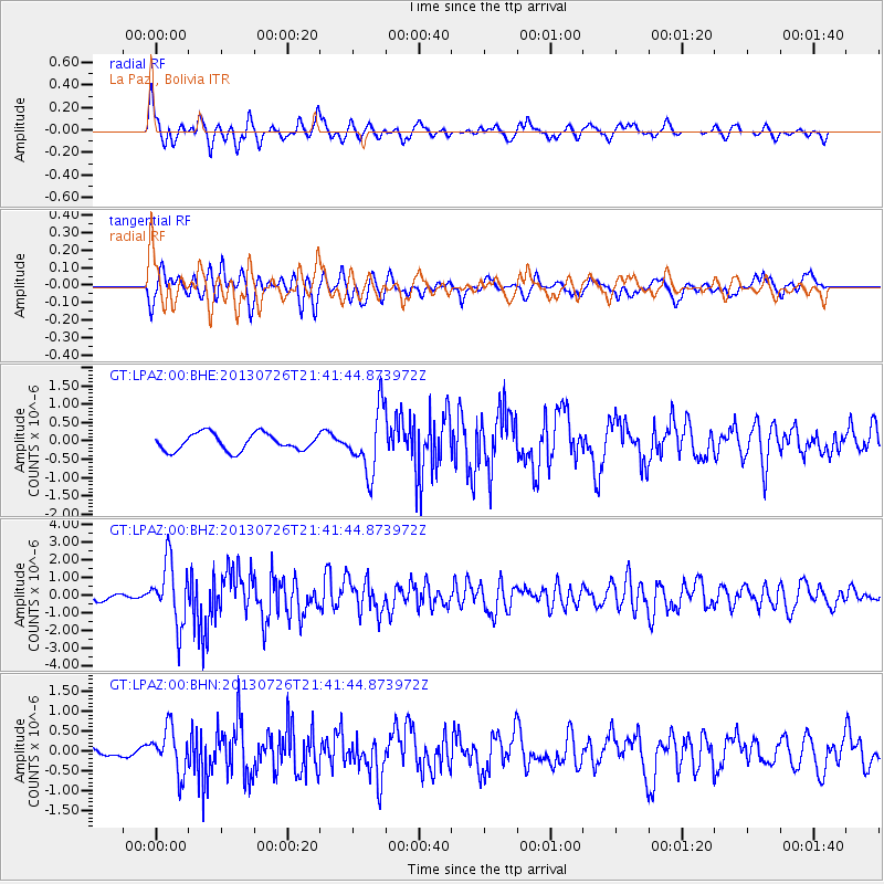
LPAZ La Paz , Bolivia - Earthquake Result Viewer
*The percent match for this event was below the threshold and hence no stack was calculated.
| Earthquake location: |
South Sandwich Islands Region |
| Earthquake latitude/longitude: |
-57.9/-23.8 |
| Earthquake time(UTC): |
2013/07/26 (207) 21:32:59 GMT |
| Earthquake Depth: |
13 km |
| Earthquake Magnitude: |
6.2 MW, 6.0 MS, 6.2 MB, 6.3 MW |
| Earthquake Catalog/Contributor: |
NEIC PDE/NEIC PDE-W |
|
| Network: |
GT Global Telemetered Seismograph Network (USAF/USGS) |
| Station: |
LPAZ La Paz , Bolivia |
| Lat/Lon: |
16.17 S/68.08 W |
| Elevation: |
4817 m |
|
| Distance: |
53.0 deg |
| Az: |
302.946 deg |
| Baz: |
152.217 deg |
| Ray Param: |
$rayparam |
*The percent match for this event was below the threshold and hence was not used in the summary stack. |
|
| Radial Match: |
74.5165 % |
| Radial Bump: |
400 |
| Transverse Match: |
68.97417 % |
| Transverse Bump: |
400 |
| SOD ConfigId: |
589702 |
| Insert Time: |
2013-09-20 03:44:54.752 +0000 |
| GWidth: |
2.5 |
| Max Bumps: |
400 |
| Tol: |
0.001 |
|
Signal To Noise
| Channel | StoN | STA | LTA |
| GT:LPAZ:00:BHZ:20130726T21:41:44.873972Z | 8.368239 | 1.7701863E-6 | 2.1153627E-7 |
| GT:LPAZ:00:BHN:20130726T21:41:44.873972Z | 8.721512 | 5.657748E-7 | 6.487119E-8 |
| GT:LPAZ:00:BHE:20130726T21:41:44.873972Z | 3.6952124 | 8.769521E-7 | 2.3732115E-7 |
| Arrivals |
| Ps | |
| PpPs | |
| PsPs/PpSs | |


