You are here: Home > Network List > IU - Global Seismograph Network (GSN - IRIS/USGS) Stations List
> Station TEIG Tepich, Yucatan, Mexico > Earthquake Result Viewer
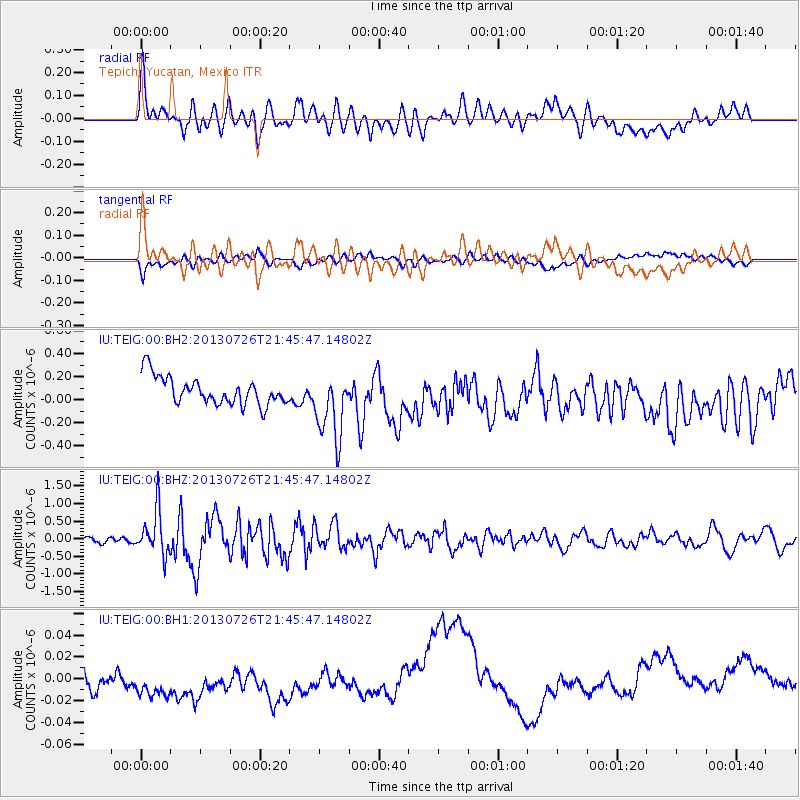
TEIG Tepich, Yucatan, Mexico - Earthquake Result Viewer
*The percent match for this event was below the threshold and hence no stack was calculated.
| Earthquake location: |
South Sandwich Islands Region |
| Earthquake latitude/longitude: |
-57.9/-23.8 |
| Earthquake time(UTC): |
2013/07/26 (207) 21:32:59 GMT |
| Earthquake Depth: |
13 km |
| Earthquake Magnitude: |
6.2 MW, 6.0 MS, 6.2 MB, 6.3 MW |
| Earthquake Catalog/Contributor: |
NEIC PDE/NEIC PDE-W |
|
| Network: |
IU Global Seismograph Network (GSN - IRIS/USGS) |
| Station: |
TEIG Tepich, Yucatan, Mexico |
| Lat/Lon: |
20.23 N/88.28 W |
| Elevation: |
40 m |
|
| Distance: |
94.3 deg |
| Az: |
301.843 deg |
| Baz: |
151.13 deg |
| Ray Param: |
$rayparam |
*The percent match for this event was below the threshold and hence was not used in the summary stack. |
|
| Radial Match: |
53.179745 % |
| Radial Bump: |
400 |
| Transverse Match: |
40.43371 % |
| Transverse Bump: |
400 |
| SOD ConfigId: |
589702 |
| Insert Time: |
2013-09-20 03:45:48.640 +0000 |
| GWidth: |
2.5 |
| Max Bumps: |
400 |
| Tol: |
0.001 |
|
Signal To Noise
| Channel | StoN | STA | LTA |
| IU:TEIG:00:BHZ:20130726T21:45:47.14802Z | 7.2023168 | 6.2671813E-7 | 8.701619E-8 |
| IU:TEIG:00:BH1:20130726T21:45:47.14802Z | 2.0832665 | 2.6979716E-8 | 1.2950678E-8 |
| IU:TEIG:00:BH2:20130726T21:45:47.14802Z | 2.4404767 | 2.9245479E-7 | 1.1983511E-7 |
| Arrivals |
| Ps | |
| PpPs | |
| PsPs/PpSs | |


