You are here: Home > Network List > WI - West Indies IPGP Network Stations List
> Station BIM Morne Bigot, Anses d'Arlets, Martinique > Earthquake Result Viewer
BIM Morne Bigot, Anses d'Arlets, Martinique - Earthquake Result Viewer
| Earthquake location: |
South Sandwich Islands Region |
| Earthquake latitude/longitude: |
-57.9/-23.8 |
| Earthquake time(UTC): |
2013/07/26 (207) 21:32:59 GMT |
| Earthquake Depth: |
13 km |
| Earthquake Magnitude: |
6.2 MW, 6.0 MS, 6.2 MB, 6.3 MW |
| Earthquake Catalog/Contributor: |
NEIC PDE/NEIC PDE-W |
|
| Network: |
WI West Indies IPGP Network |
| Station: |
BIM Morne Bigot, Anses d'Arlets, Martinique |
| Lat/Lon: |
14.52 N/61.07 W |
| Elevation: |
391 m |
|
| Distance: |
78.4 deg |
| Az: |
323.268 deg |
| Baz: |
160.755 deg |
| Ray Param: |
0.04965637 |
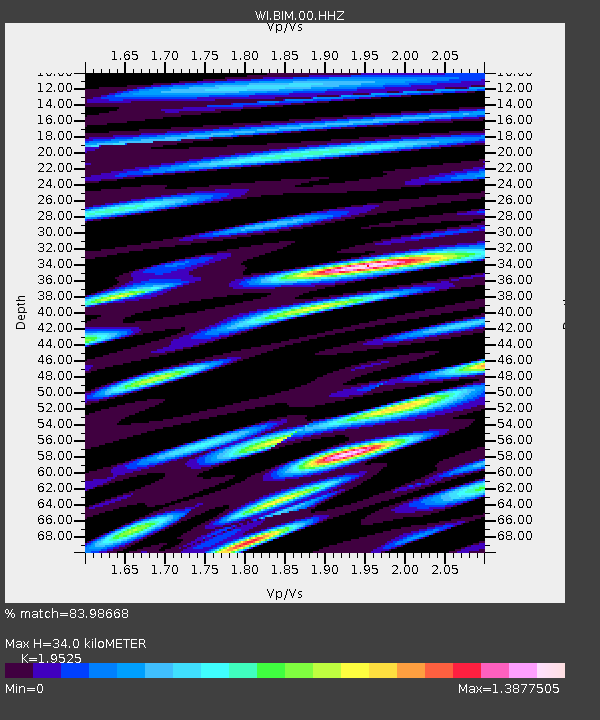
| Estimated Moho Depth: |
34.0 km |
| Estimated Crust Vp/Vs: |
1.95 |
| Assumed Crust Vp: |
5.88 km/s |
| Estimated Crust Vs: |
3.012 km/s |
| Estimated Crust Poisson's Ratio: |
0.32 |
|
| Radial Match: |
83.98668 % |
| Radial Bump: |
400 |
| Transverse Match: |
81.077866 % |
| Transverse Bump: |
400 |
| SOD ConfigId: |
589702 |
| Insert Time: |
2013-09-20 03:47:45.112 +0000 |
| GWidth: |
2.5 |
| Max Bumps: |
400 |
| Tol: |
0.001 |
|

Signal To Noise
| Channel | StoN | STA | LTA |
| WI:BIM:00:HHZ:20130726T21:44:28.830027Z | 6.804422 | 2.0715518E-6 | 3.0444198E-7 |
| WI:BIM:00:HHN:20130726T21:44:28.830027Z | 1.4929346 | 7.495492E-7 | 5.020643E-7 |
| WI:BIM:00:HHE:20130726T21:44:28.830027Z | 1.573964 | 6.0926584E-7 | 3.8709007E-7 |
| Arrivals |
| Ps | 5.6 SECOND |
| PpPs | 17 SECOND |
| PsPs/PpSs | 22 SECOND |


