You are here: Home > Network List > IU - Global Seismograph Network (GSN - IRIS/USGS) Stations List
> Station PMG Port Moresby, New Guinea > Earthquake Result Viewer
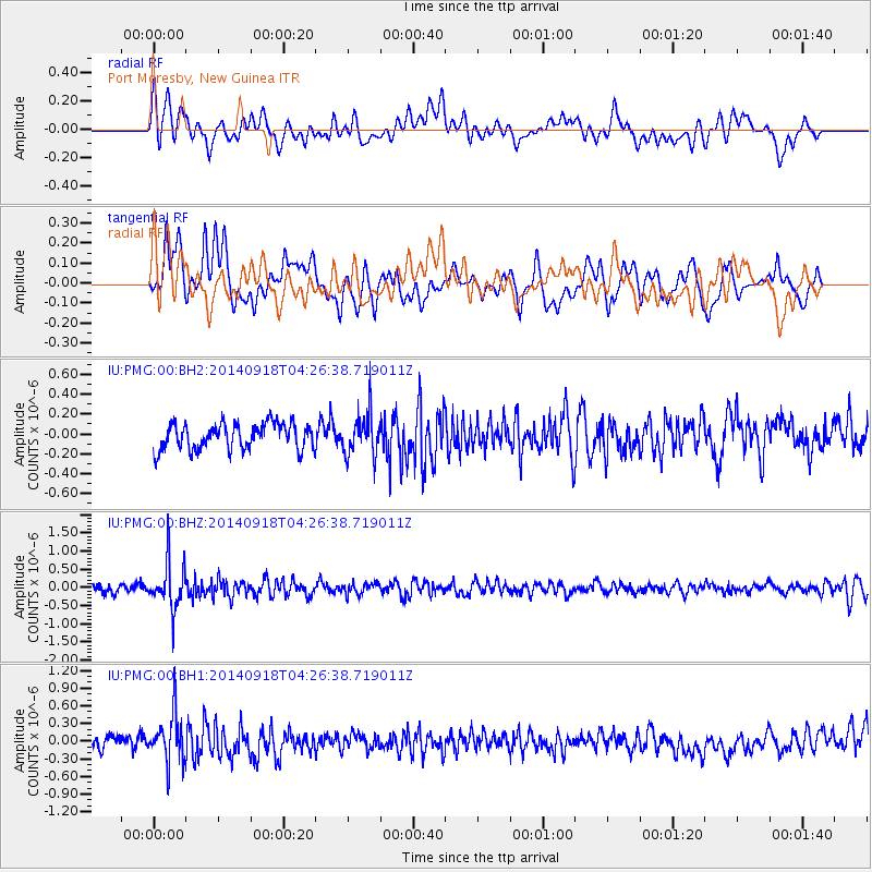
PMG Port Moresby, New Guinea - Earthquake Result Viewer
*The percent match for this event was below the threshold and hence no stack was calculated.
| Earthquake location: |
Northwest Of Kuril Islands |
| Earthquake latitude/longitude: |
50.6/150.2 |
| Earthquake time(UTC): |
2014/09/18 (261) 04:17:53 GMT |
| Earthquake Depth: |
502 km |
| Earthquake Magnitude: |
5.6 MW |
| Earthquake Catalog/Contributor: |
ISC/ISC |
|
| Network: |
IU Global Seismograph Network (GSN - IRIS/USGS) |
| Station: |
PMG Port Moresby, New Guinea |
| Lat/Lon: |
9.40 S/147.16 E |
| Elevation: |
90 m |
|
| Distance: |
59.8 deg |
| Az: |
183.443 deg |
| Baz: |
2.224 deg |
| Ray Param: |
$rayparam |
*The percent match for this event was below the threshold and hence was not used in the summary stack. |
|
| Radial Match: |
55.105488 % |
| Radial Bump: |
400 |
| Transverse Match: |
54.775497 % |
| Transverse Bump: |
400 |
| SOD ConfigId: |
3390531 |
| Insert Time: |
2019-04-14 02:45:54.724 +0000 |
| GWidth: |
2.5 |
| Max Bumps: |
400 |
| Tol: |
0.001 |
|
Signal To Noise
| Channel | StoN | STA | LTA |
| IU:PMG:00:BHZ:20140918T04:26:38.719011Z | 4.6983023 | 6.4837764E-7 | 1.3800253E-7 |
| IU:PMG:00:BH1:20140918T04:26:38.719011Z | 4.376003 | 4.077691E-7 | 9.318301E-8 |
| IU:PMG:00:BH2:20140918T04:26:38.719011Z | 1.6095178 | 2.0765509E-7 | 1.2901695E-7 |
| Arrivals |
| Ps | |
| PpPs | |
| PsPs/PpSs | |


