You are here: Home > Network List > IU - Global Seismograph Network (GSN - IRIS/USGS) Stations List
> Station RSSD Black Hills, South Dakota, USA > Earthquake Result Viewer
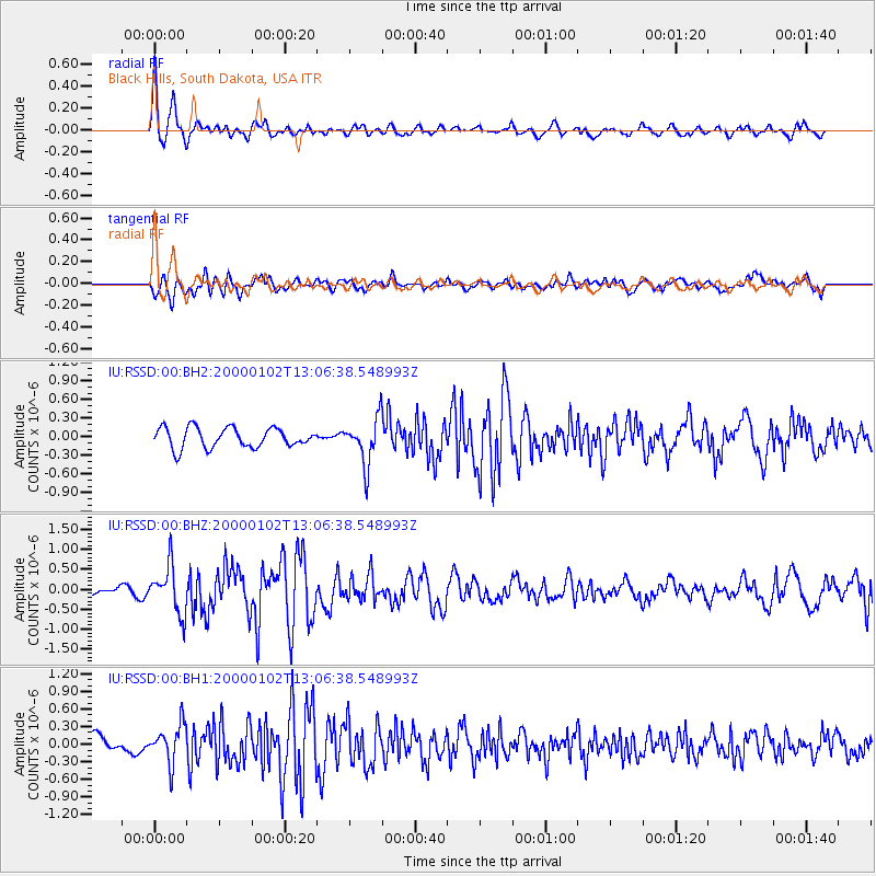
RSSD Black Hills, South Dakota, USA - Earthquake Result Viewer
*The percent match for this event was below the threshold and hence no stack was calculated.
| Earthquake location: |
Andreanof Islands, Aleutian Is. |
| Earthquake latitude/longitude: |
51.4/-175.6 |
| Earthquake time(UTC): |
2000/01/02 (002) 12:58:42 GMT |
| Earthquake Depth: |
33 km |
| Earthquake Magnitude: |
5.6 MB, 5.4 MS, 5.8 MW, 5.8 MW |
| Earthquake Catalog/Contributor: |
WHDF/NEIC |
|
| Network: |
IU Global Seismograph Network (GSN - IRIS/USGS) |
| Station: |
RSSD Black Hills, South Dakota, USA |
| Lat/Lon: |
44.12 N/104.04 W |
| Elevation: |
2060 m |
|
| Distance: |
46.8 deg |
| Az: |
69.448 deg |
| Baz: |
305.551 deg |
| Ray Param: |
$rayparam |
*The percent match for this event was below the threshold and hence was not used in the summary stack. |
|
| Radial Match: |
74.880745 % |
| Radial Bump: |
400 |
| Transverse Match: |
65.93093 % |
| Transverse Bump: |
400 |
| SOD ConfigId: |
590571 |
| Insert Time: |
2013-09-24 16:56:10.598 +0000 |
| GWidth: |
2.5 |
| Max Bumps: |
400 |
| Tol: |
0.001 |
|
Signal To Noise
| Channel | StoN | STA | LTA |
| IU:RSSD:00:BHZ:20000102T13:06:38.548993Z | 4.143587 | 5.92292E-7 | 1.4294184E-7 |
| IU:RSSD:00:BH1:20000102T13:06:38.548993Z | 2.1945786 | 3.2603788E-7 | 1.4856514E-7 |
| IU:RSSD:00:BH2:20000102T13:06:38.548993Z | 2.3472874 | 3.719591E-7 | 1.5846338E-7 |
| Arrivals |
| Ps | |
| PpPs | |
| PsPs/PpSs | |


