You are here: Home > Network List > IU - Global Seismograph Network (GSN - IRIS/USGS) Stations List
> Station POHA Pohakuloa, Hawaii, USA > Earthquake Result Viewer
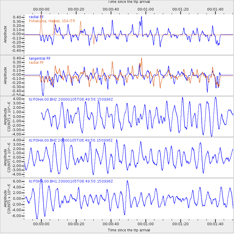
POHA Pohakuloa, Hawaii, USA - Earthquake Result Viewer
*The percent match for this event was below the threshold and hence no stack was calculated.
| Earthquake location: |
Santa Cruz Islands |
| Earthquake latitude/longitude: |
-11.5/165.4 |
| Earthquake time(UTC): |
2000/01/05 (005) 08:41:40 GMT |
| Earthquake Depth: |
33 km |
| Earthquake Magnitude: |
5.5 MW |
| Earthquake Catalog/Contributor: |
NEIC PDE/NEIC PDE-M |
|
| Network: |
IU Global Seismograph Network (GSN - IRIS/USGS) |
| Station: |
POHA Pohakuloa, Hawaii, USA |
| Lat/Lon: |
19.76 N/155.53 W |
| Elevation: |
1967 m |
|
| Distance: |
49.4 deg |
| Az: |
51.394 deg |
| Baz: |
234.426 deg |
| Ray Param: |
$rayparam |
*The percent match for this event was below the threshold and hence was not used in the summary stack. |
|
| Radial Match: |
49.371952 % |
| Radial Bump: |
347 |
| Transverse Match: |
49.108234 % |
| Transverse Bump: |
376 |
| SOD ConfigId: |
590571 |
| Insert Time: |
2013-09-24 16:56:54.666 +0000 |
| GWidth: |
2.5 |
| Max Bumps: |
400 |
| Tol: |
0.001 |
|
Signal To Noise
| Channel | StoN | STA | LTA |
| IU:POHA:00:BHZ:20000105T08:49:56.150996Z | 0.609099 | 1.1339109E-6 | 1.8616201E-6 |
| IU:POHA:00:BH1:20000105T08:49:56.150996Z | 3.7976296 | 4.4491712E-6 | 1.1715654E-6 |
| IU:POHA:00:BH2:20000105T08:49:56.150996Z | 1.2426574 | 1.8622438E-6 | 1.4985978E-6 |
| Arrivals |
| Ps | |
| PpPs | |
| PsPs/PpSs | |


