You are here: Home > Network List > IU - Global Seismograph Network (GSN - IRIS/USGS) Stations List
> Station RSSD Black Hills, South Dakota, USA > Earthquake Result Viewer
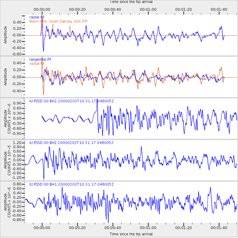
RSSD Black Hills, South Dakota, USA - Earthquake Result Viewer
*The percent match for this event was below the threshold and hence no stack was calculated.
| Earthquake location: |
Northern Alaska |
| Earthquake latitude/longitude: |
65.0/-154.2 |
| Earthquake time(UTC): |
2000/02/03 (034) 10:24:59 GMT |
| Earthquake Depth: |
7.3 km |
| Earthquake Magnitude: |
5.7 MW, 6.1 ML |
| Earthquake Catalog/Contributor: |
NEIC PDE/NEIC PDE-M |
|
| Network: |
IU Global Seismograph Network (GSN - IRIS/USGS) |
| Station: |
RSSD Black Hills, South Dakota, USA |
| Lat/Lon: |
44.12 N/104.04 W |
| Elevation: |
2060 m |
|
| Distance: |
34.5 deg |
| Az: |
102.503 deg |
| Baz: |
324.85 deg |
| Ray Param: |
$rayparam |
*The percent match for this event was below the threshold and hence was not used in the summary stack. |
|
| Radial Match: |
60.39893 % |
| Radial Bump: |
400 |
| Transverse Match: |
65.97372 % |
| Transverse Bump: |
400 |
| SOD ConfigId: |
590571 |
| Insert Time: |
2013-09-24 17:18:34.310 +0000 |
| GWidth: |
2.5 |
| Max Bumps: |
400 |
| Tol: |
0.001 |
|
Signal To Noise
| Channel | StoN | STA | LTA |
| IU:RSSD:00:BHZ:20000203T10:31:17.048005Z | 3.6463661 | 4.799987E-7 | 1.3163753E-7 |
| IU:RSSD:00:BH1:20000203T10:31:17.048005Z | 1.0872961 | 1.7199295E-7 | 1.5818411E-7 |
| IU:RSSD:00:BH2:20000203T10:31:17.048005Z | 4.774087 | 5.4404615E-7 | 1.1395816E-7 |
| Arrivals |
| Ps | |
| PpPs | |
| PsPs/PpSs | |


