You are here: Home > Network List > IU - Global Seismograph Network (GSN - IRIS/USGS) Stations List
> Station JOHN Johnston Island, USA > Earthquake Result Viewer
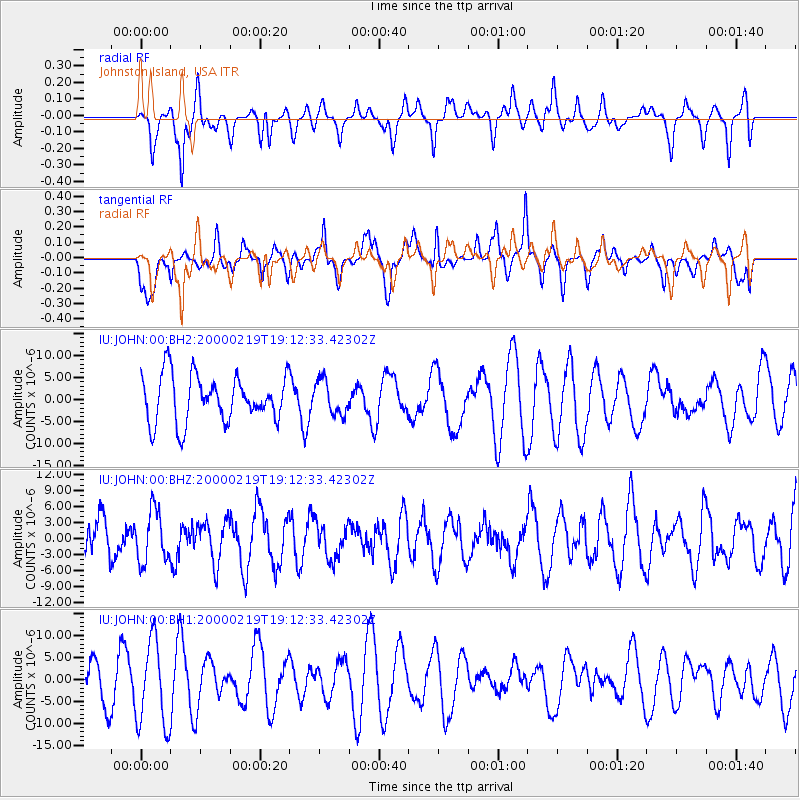
JOHN Johnston Island, USA - Earthquake Result Viewer
*The percent match for this event was below the threshold and hence no stack was calculated.
| Earthquake location: |
Minahassa Peninsula, Sulawesi |
| Earthquake latitude/longitude: |
1.3/120.8 |
| Earthquake time(UTC): |
2000/02/19 (050) 19:01:55 GMT |
| Earthquake Depth: |
33 km |
| Earthquake Magnitude: |
5.6 MB |
| Earthquake Catalog/Contributor: |
NEIC PDE/NEIC PDE-M |
|
| Network: |
IU Global Seismograph Network (GSN - IRIS/USGS) |
| Station: |
JOHN Johnston Island, USA |
| Lat/Lon: |
16.73 N/169.53 W |
| Elevation: |
2.0 m |
|
| Distance: |
70.1 deg |
| Az: |
72.759 deg |
| Baz: |
265.208 deg |
| Ray Param: |
$rayparam |
*The percent match for this event was below the threshold and hence was not used in the summary stack. |
|
| Radial Match: |
61.422207 % |
| Radial Bump: |
359 |
| Transverse Match: |
61.923157 % |
| Transverse Bump: |
400 |
| SOD ConfigId: |
590571 |
| Insert Time: |
2013-09-24 17:21:23.514 +0000 |
| GWidth: |
2.5 |
| Max Bumps: |
400 |
| Tol: |
0.001 |
|
Signal To Noise
| Channel | StoN | STA | LTA |
| IU:JOHN:00:BHZ:20000219T19:12:33.42302Z | 1.0524865 | 4.862077E-6 | 4.619609E-6 |
| IU:JOHN:00:BH1:20000219T19:12:33.42302Z | 2.594639 | 9.797654E-6 | 3.7761142E-6 |
| IU:JOHN:00:BH2:20000219T19:12:33.42302Z | 0.7213128 | 3.8548656E-6 | 5.3442354E-6 |
| Arrivals |
| Ps | |
| PpPs | |
| PsPs/PpSs | |


