You are here: Home > Network List > IU - Global Seismograph Network (GSN - IRIS/USGS) Stations List
> Station POHA Pohakuloa, Hawaii, USA > Earthquake Result Viewer
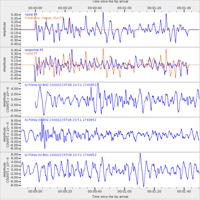
POHA Pohakuloa, Hawaii, USA - Earthquake Result Viewer
*The percent match for this event was below the threshold and hence no stack was calculated.
| Earthquake location: |
Mariana Islands |
| Earthquake latitude/longitude: |
13.8/144.8 |
| Earthquake time(UTC): |
2000/02/26 (057) 08:11:48 GMT |
| Earthquake Depth: |
132 km |
| Earthquake Magnitude: |
6.0 MB, 5.4 MS, 6.2 MW, 6.2 MW |
| Earthquake Catalog/Contributor: |
WHDF/NEIC |
|
| Network: |
IU Global Seismograph Network (GSN - IRIS/USGS) |
| Station: |
POHA Pohakuloa, Hawaii, USA |
| Lat/Lon: |
19.76 N/155.53 W |
| Elevation: |
1967 m |
|
| Distance: |
57.2 deg |
| Az: |
75.266 deg |
| Baz: |
273.982 deg |
| Ray Param: |
$rayparam |
*The percent match for this event was below the threshold and hence was not used in the summary stack. |
|
| Radial Match: |
53.783794 % |
| Radial Bump: |
400 |
| Transverse Match: |
54.112976 % |
| Transverse Bump: |
400 |
| SOD ConfigId: |
590571 |
| Insert Time: |
2013-09-24 17:24:05.407 +0000 |
| GWidth: |
2.5 |
| Max Bumps: |
400 |
| Tol: |
0.001 |
|
Signal To Noise
| Channel | StoN | STA | LTA |
| IU:POHA:00:BHZ:20000226T08:20:51.174985Z | 1.7101821 | 2.7717685E-6 | 1.6207448E-6 |
| IU:POHA:00:BH1:20000226T08:20:51.174985Z | 1.2513186 | 2.9429063E-6 | 2.3518442E-6 |
| IU:POHA:00:BH2:20000226T08:20:51.174985Z | 0.5558962 | 1.1572012E-6 | 2.0816856E-6 |
| Arrivals |
| Ps | |
| PpPs | |
| PsPs/PpSs | |


