You are here: Home > Network List > IU - Global Seismograph Network (GSN - IRIS/USGS) Stations List
> Station POHA Pohakuloa, Hawaii, USA > Earthquake Result Viewer
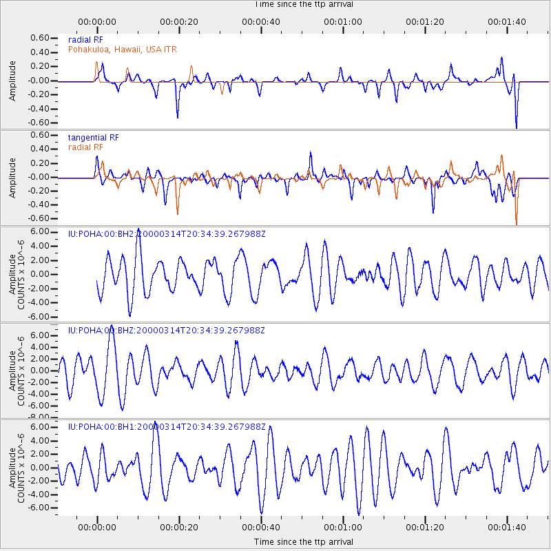
POHA Pohakuloa, Hawaii, USA - Earthquake Result Viewer
*The percent match for this event was below the threshold and hence no stack was calculated.
| Earthquake location: |
Balleny Islands Region |
| Earthquake latitude/longitude: |
-61.8/160.8 |
| Earthquake time(UTC): |
2000/03/14 (074) 20:22:18 GMT |
| Earthquake Depth: |
10 km |
| Earthquake Magnitude: |
5.6 MW |
| Earthquake Catalog/Contributor: |
NEIC PDE/NEIC PDE-M |
|
| Network: |
IU Global Seismograph Network (GSN - IRIS/USGS) |
| Station: |
POHA Pohakuloa, Hawaii, USA |
| Lat/Lon: |
19.76 N/155.53 W |
| Elevation: |
1967 m |
|
| Distance: |
88.4 deg |
| Az: |
40.571 deg |
| Baz: |
199.168 deg |
| Ray Param: |
$rayparam |
*The percent match for this event was below the threshold and hence was not used in the summary stack. |
|
| Radial Match: |
61.06167 % |
| Radial Bump: |
400 |
| Transverse Match: |
51.82936 % |
| Transverse Bump: |
400 |
| SOD ConfigId: |
590571 |
| Insert Time: |
2013-09-24 17:29:01.560 +0000 |
| GWidth: |
2.5 |
| Max Bumps: |
400 |
| Tol: |
0.001 |
|
Signal To Noise
| Channel | StoN | STA | LTA |
| IU:POHA:00:BHZ:20000314T20:34:39.267988Z | 2.6694357 | 4.6763657E-6 | 1.751818E-6 |
| IU:POHA:00:BH1:20000314T20:34:39.267988Z | 0.8778455 | 1.9878544E-6 | 2.2644695E-6 |
| IU:POHA:00:BH2:20000314T20:34:39.267988Z | 1.0112493 | 2.4147228E-6 | 2.3878608E-6 |
| Arrivals |
| Ps | |
| PpPs | |
| PsPs/PpSs | |


