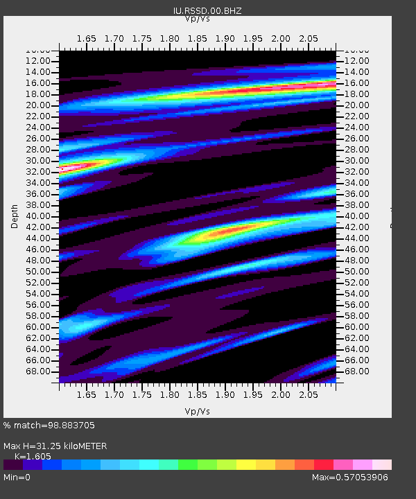
RSSD Black Hills, South Dakota, USA - Earthquake Result Viewer
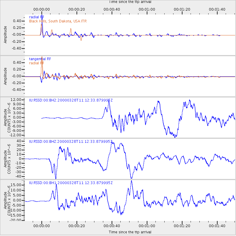
Earthquake location: Volcano Islands, Japan Region
Earthquake latitude/longitude: 22.3/143.7
Earthquake time(UTC): 2000/03/28 (088) 11:00:22 GMT
Earthquake Depth: 126 km
Earthquake Magnitude: 6.8 MB, 7.6 MS, 7.6 MW, 7.6 MW
Earthquake Catalog/Contributor: WHDF/NEIC
Network: IU Global Seismograph Network (GSN - IRIS/USGS)
Station: RSSD Black Hills, South Dakota, USA
Lat/Lon: 44.12 N/104.04 W
Elevation: 2060 m
Distance: 89.4 deg
Az: 41.812 deg
Baz: 301.013 deg
Ray Param: 0.041719038
Estimated Moho Depth: 31.25 km
Estimated Crust Vp/Vs: 1.61
Assumed Crust Vp: 6.242 km/s
Estimated Crust Vs: 3.889 km/s
Estimated Crust Poisson's Ratio: 0.18
Radial Match: 98.883705 %
Radial Bump: 276
Transverse Match: 93.84939 %
Transverse Bump: 400
SOD ConfigId: 590571
Insert Time: 2013-09-24 17:31:30.626 +0000
GWidth: 2.5
Max Bumps: 400
Tol: 0.001

Signal To Noise

ChannelStoNSTALTA
IU:RSSD:00:BHZ:20000328T11:12:33.879995Z3.49116641.2205392E-63.4960786E-7
IU:RSSD:00:BH1:20000328T11:12:33.879995Z1.32611532.594517E-71.9564791E-7
IU:RSSD:00:BH2:20000328T11:12:33.879995Z1.68827263.243612E-71.9212608E-7
Arrivals
Ps3.1 SECOND
PpPs13 SECOND
PsPs/PpSs16 SECOND