You are here: Home > Network List > IU - Global Seismograph Network (GSN - IRIS/USGS) Stations List
> Station RSSD Black Hills, South Dakota, USA > Earthquake Result Viewer
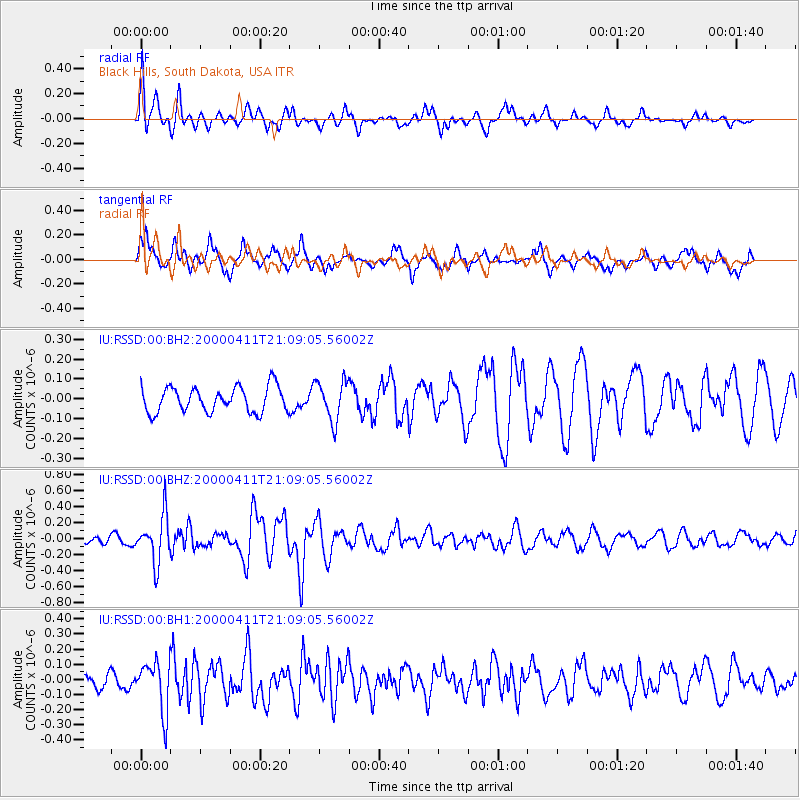
RSSD Black Hills, South Dakota, USA - Earthquake Result Viewer
*The percent match for this event was below the threshold and hence no stack was calculated.
| Earthquake location: |
Tonga Islands |
| Earthquake latitude/longitude: |
-15.6/-173.3 |
| Earthquake time(UTC): |
2000/04/11 (102) 20:56:59 GMT |
| Earthquake Depth: |
54 km |
| Earthquake Magnitude: |
5.7 MW, 5.7 MW, 5.7 MB |
| Earthquake Catalog/Contributor: |
NEIC PDE/NEIC PDE-M |
|
| Network: |
IU Global Seismograph Network (GSN - IRIS/USGS) |
| Station: |
RSSD Black Hills, South Dakota, USA |
| Lat/Lon: |
44.12 N/104.04 W |
| Elevation: |
2060 m |
|
| Distance: |
86.5 deg |
| Az: |
42.449 deg |
| Baz: |
244.58 deg |
| Ray Param: |
$rayparam |
*The percent match for this event was below the threshold and hence was not used in the summary stack. |
|
| Radial Match: |
66.664 % |
| Radial Bump: |
400 |
| Transverse Match: |
65.71213 % |
| Transverse Bump: |
370 |
| SOD ConfigId: |
590571 |
| Insert Time: |
2013-09-24 18:07:49.911 +0000 |
| GWidth: |
2.5 |
| Max Bumps: |
400 |
| Tol: |
0.001 |
|
Signal To Noise
| Channel | StoN | STA | LTA |
| IU:RSSD:00:BHZ:20000411T21:09:05.56002Z | 5.768562 | 2.9542326E-7 | 5.1212638E-8 |
| IU:RSSD:00:BH1:20000411T21:09:05.56002Z | 2.1084263 | 1.6357131E-7 | 7.7579806E-8 |
| IU:RSSD:00:BH2:20000411T21:09:05.56002Z | 1.5916023 | 1.0095956E-7 | 6.343266E-8 |
| Arrivals |
| Ps | |
| PpPs | |
| PsPs/PpSs | |


