You are here: Home > Network List > IU - Global Seismograph Network (GSN - IRIS/USGS) Stations List
> Station RSSD Black Hills, South Dakota, USA > Earthquake Result Viewer
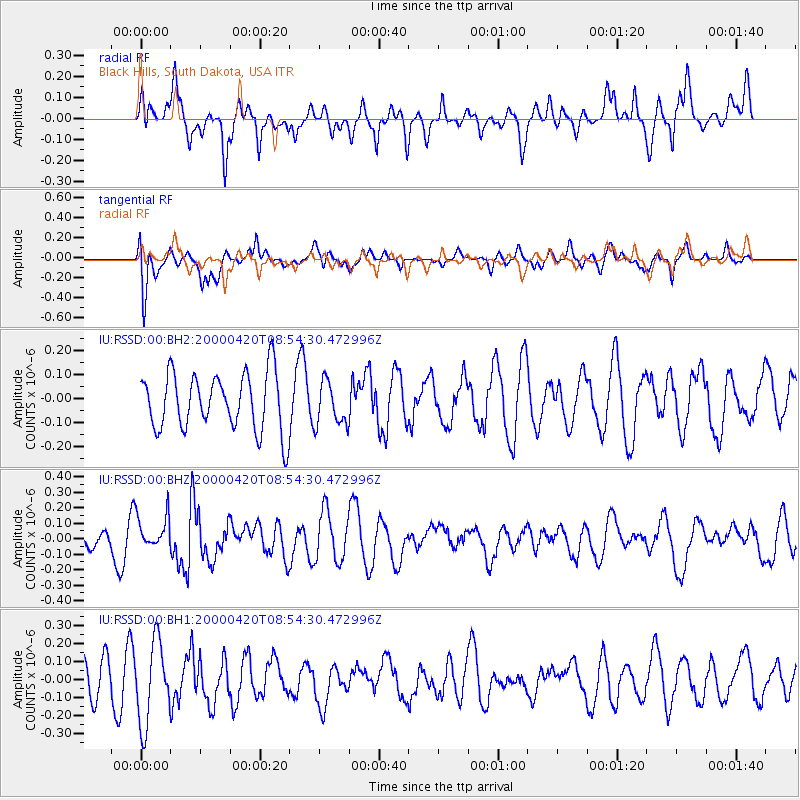
RSSD Black Hills, South Dakota, USA - Earthquake Result Viewer
*The percent match for this event was below the threshold and hence no stack was calculated.
| Earthquake location: |
Southeastern Uzbekistan |
| Earthquake latitude/longitude: |
38.6/66.4 |
| Earthquake time(UTC): |
2000/04/20 (111) 08:41:29 GMT |
| Earthquake Depth: |
10 km |
| Earthquake Magnitude: |
5.5 MB |
| Earthquake Catalog/Contributor: |
NEIC PDE/NEIC PDE-M |
|
| Network: |
IU Global Seismograph Network (GSN - IRIS/USGS) |
| Station: |
RSSD Black Hills, South Dakota, USA |
| Lat/Lon: |
44.12 N/104.04 W |
| Elevation: |
2060 m |
|
| Distance: |
97.2 deg |
| Az: |
353.105 deg |
| Baz: |
7.503 deg |
| Ray Param: |
$rayparam |
*The percent match for this event was below the threshold and hence was not used in the summary stack. |
|
| Radial Match: |
48.372524 % |
| Radial Bump: |
393 |
| Transverse Match: |
61.68051 % |
| Transverse Bump: |
400 |
| SOD ConfigId: |
590571 |
| Insert Time: |
2013-09-24 18:09:30.375 +0000 |
| GWidth: |
2.5 |
| Max Bumps: |
400 |
| Tol: |
0.001 |
|
Signal To Noise
| Channel | StoN | STA | LTA |
| IU:RSSD:00:BHZ:20000420T08:54:30.472996Z | 1.3330481 | 1.06224974E-7 | 7.9685776E-8 |
| IU:RSSD:00:BH1:20000420T08:54:30.472996Z | 2.7029207 | 2.2870634E-7 | 8.461452E-8 |
| IU:RSSD:00:BH2:20000420T08:54:30.472996Z | 0.7706958 | 9.152342E-8 | 1.1875427E-7 |
| Arrivals |
| Ps | |
| PpPs | |
| PsPs/PpSs | |


